Yuanren geodata
Yuanren (Shaanxi) is a seat of a fourth-order administrative division; located in China in Asia/Shanghai (GMT+8) time zone. In our database, there are 1268 cities with bigger population. Compared to other cities in China, 74.2% of cities are located further ↓South; 74.2% of cities are located further →East and 68.9% of cities have lower elevation than Yuanren. Note1


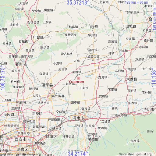
Yuanren GPS coordinates[2]
34° 47' 48.516" North, 109° 27' 17.532" East
| Map corner | latitude | longitude |
|---|---|---|
| Upper-left | 35.37218°, | 108.75175° |
| Center: | 34.79681°, | 109.45487° |
| Lower-right: | 34.2174°, | 110.158° |
| Map W x H: | 128.4×128.4 km | = 79.8×79.8mi |
| max Lat: | 53.31946° ⇑25.8% North |
| Yuanren: | 34.79681° |
| min Lat: | ⇓74.2% South 18.22056° |
| min Long | Yuanren | max Long |
| 75.07348° | 109.45487° | 134.28917° |
| W 25.8%⇐ | ⇒74.2% E |
Elevation
Elevation of Yuanren is 391 m = 1283 ft, and this is 93.8 m = 308 ft below average elevation for this country.
| Max E: |
5622 m = 18445 ft | 31.1% |
| Avg. | 484.8 m = 1591 ft | |
| Yuanren | 391 m = 1283 ft | |
Min E: |
-3 m = -10 ft | 68.9% |
See also: China elevation on elevation.city.
Geographical zone
Yuanren is located in North temperate zone (between Tropic of Cancer and the Arctic Circle). Distance of this Northern Tropic circle is 1263.1 km =784.9 mi to South.| Distance of | km | miles | from Yuanren |
|---|---|---|---|
| North Pole | 6138 | 3814 | to North |
| Arctic Circle | 3532.1 | 2194.7 | to North |
| Tropic Cancer | 1263.1 | 784.9 | to South |
| Equator | 3869 | 2404.1 | to South |


Nearby cities:
15 places around Yuanren: (largest is in red/bold)
• Chenzhuang
16 km =9.9 mi,  58°
58°
• Dangmu
15.3 km =9.5 mi,  82°
82°
• Daoxian
14.5 km =9 mi,  298°
298°
• Guandi
9.4 km =5.8 mi,  186°
186°
• Guanshan
13.6 km =8.5 mi,  211°
211°
• Jiaqu
15.6 km =9.7 mi,  30°
30°
• Jingyao
5.5 km =3.4 mi,  349°
349°
• Lindian
15.8 km =9.8 mi,  121°
121°
• Liugu
17.2 km =10.7 mi,  250°
250°
• Liuji
13.8 km =8.6 mi,  259°
259°
• Shijia
6.9 km =4.3 mi,  289°
289°
• Sufang
13.4 km =8.3 mi,  325°
325°
• Xiaji
9.2 km =5.7 mi,  148°
148°
• Xingzhen
15.1 km =9.4 mi,  357°
357°
• Zhangqiao
8.1 km =5 mi,  235°
235°
Sources, notices
• [Note1] Compared only with cities in China existing in our database
• [Src1] Map data: © OpenStreetMap contributors (CC-BY-SA)
• [Src2] Other city data from geonames.org with taken over terms of usage.
• [Src3] Geographical zone / Annual Mean Temperature by Robert A. Rohde @ Wikipedia
