Lindian geodata
Lindian (Shaanxi) is a seat of a fourth-order administrative division; located in China in Asia/Shanghai (GMT+8) time zone. In our database, there are 1268 cities with bigger population. Compared to other cities in China, 73.9% of cities are located further ↓South; 73.3% of cities are located further →East and 66.5% of cities have lower elevation than Lindian. Note1


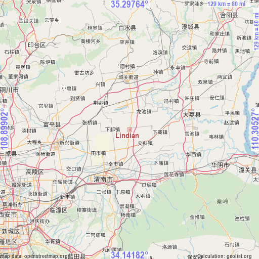
Lindian GPS coordinates[2]
34° 43' 18.3" North, 109° 36' 7.704" East
| Map corner | latitude | longitude |
|---|---|---|
| Upper-left | 35.29764°, | 108.89902° |
| Center: | 34.72175°, | 109.60214° |
| Lower-right: | 34.14182°, | 110.30527° |
| Map W x H: | 128.5×128.5 km | = 79.8×79.8mi |
| max Lat: | 53.31946° ⇑26.1% North |
| Lindian: | 34.72175° |
| min Lat: | ⇓73.9% South 18.22056° |
| min Long | Lindian | max Long |
| 75.07348° | 109.60214° | 134.28917° |
| W 26.7%⇐ | ⇒73.3% E |
Elevation
Elevation of Lindian is 352 m = 1155 ft, and this is 132.8 m = 436 ft below average elevation for this country.
| Max E: |
5622 m = 18445 ft | 33.5% |
| Avg. | 484.8 m = 1591 ft | |
| Lindian | 352 m = 1155 ft | |
Min E: |
-3 m = -10 ft | 66.5% |
See also: China elevation on elevation.city.
Geographical zone
Lindian is located in North temperate zone (between Tropic of Cancer and the Arctic Circle). Distance of this Northern Tropic circle is 1254.8 km =779.7 mi to South.| Distance of | km | miles | from Lindian |
|---|---|---|---|
| North Pole | 6146.4 | 3819.2 | to North |
| Arctic Circle | 3540.5 | 2200 | to North |
| Tropic Cancer | 1254.8 | 779.7 | to South |
| Equator | 3860.7 | 2398.9 | to South |


Nearby cities:
15 places around Lindian: (largest is in red/bold)
• Chenzhuang
16.7 km =10.4 mi,  0°
0°
• Dangmu
10.4 km =6.5 mi,  9°
9°
• Guandao
14.9 km =9.3 mi,  226°
226°
• Guandi
14.6 km =9.1 mi,  266°
266°
• Guanlu
11.1 km =6.9 mi,  80°
80°
• Gushi
9 km =5.6 mi,  190°
190°
• Jiaoxie
9.9 km =6.2 mi,  129°
129°
• Longchi
11.6 km =7.2 mi,  35°
35°
• Longyang
15.8 km =9.8 mi,  29°
29°
• Nanshi
8.2 km =5.1 mi,  163°
163°
• Xiaji
8.7 km =5.4 mi, 273°
• Xiaoyi
14.8 km =9.2 mi,  141°
141°
• Xiazhai
14.9 km =9.3 mi,  93°
93°
• Yuanren
15.8 km =9.8 mi,  301°
301°
• Zhangjia
16.9 km =10.5 mi, 133°
Sources, notices
• [Note1] Compared only with cities in China existing in our database
• [Src1] Map data: © OpenStreetMap contributors (CC-BY-SA)
• [Src2] Other city data from geonames.org with taken over terms of usage.
• [Src3] Geographical zone / Annual Mean Temperature by Robert A. Rohde @ Wikipedia
