Dangmu geodata
Dangmu (Shaanxi) is a seat of a fourth-order administrative division; located in China in Asia/Shanghai (GMT+8) time zone. In our database, there are 1268 cities with bigger population. Compared to other cities in China, 74.3% of cities are located further ↓South; 73.2% of cities are located further →East and 68% of cities have lower elevation than Dangmu. Note1


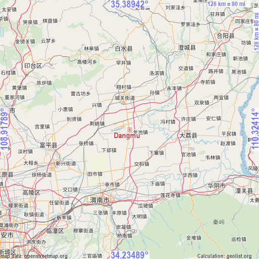
Dangmu GPS coordinates[2]
34° 48' 51.048" North, 109° 37' 15.636" East
| Map corner | latitude | longitude |
|---|---|---|
| Upper-left | 35.38942°, | 108.91789° |
| Center: | 34.81418°, | 109.62101° |
| Lower-right: | 34.23489°, | 110.32414° |
| Map W x H: | 128.4×128.4 km | = 79.8×79.8mi |
| max Lat: | 53.31946° ⇑25.7% North |
| Dangmu: | 34.81418° |
| min Lat: | ⇓74.3% South 18.22056° |
| min Long | Dangmu | max Long |
| 75.07348° | 109.62101° | 134.28917° |
| W 26.8%⇐ | ⇒73.2% E |
Elevation
Elevation of Dangmu is 377 m = 1237 ft, and this is 107.8 m = 354 ft below average elevation for this country.
| Max E: |
5622 m = 18445 ft | 32% |
| Avg. | 484.8 m = 1591 ft | |
| Dangmu | 377 m = 1237 ft | |
Min E: |
-3 m = -10 ft | 68% |
See also: China elevation on elevation.city.
Geographical zone
Dangmu is located in North temperate zone (between Tropic of Cancer and the Arctic Circle). Distance of this Northern Tropic circle is 1265.1 km =786.1 mi to South.| Distance of | km | miles | from Dangmu |
|---|---|---|---|
| North Pole | 6136.1 | 3812.8 | to North |
| Arctic Circle | 3530.2 | 2193.6 | to North |
| Tropic Cancer | 1265.1 | 786.1 | to South |
| Equator | 3871 | 2405.3 | to South |


Nearby cities:
15 places around Dangmu: (largest is in red/bold)
• Chenzhuang
6.6 km =4.1 mi,  346°
346°
• Chunlin
17 km =10.6 mi,  17°
17°
• Dongyang
12.6 km =7.8 mi,  3°
3°
• Guanlu
12.5 km =7.8 mi,  132°
132°
• Jiaoxie
17.6 km =10.9 mi,  160°
160°
• Jiaqu
13.6 km =8.5 mi,  327°
327°
• Jingyao
16.5 km =10.3 mi,  282°
282°
• Lindian
10.4 km =6.5 mi,  189°
189°
• Longchi
5.2 km =3.2 mi,  99°
99°
• Longyang
7 km =4.3 mi,  60°
60°
• Pinglumiao
14.8 km =9.2 mi,  44°
44°
• Pucheng Chengguanzhen
16.1 km =10 mi, 347°
• Xiaji
14.3 km =8.9 mi,  226°
226°
• Xiazhai
17.2 km =10.7 mi, 130°
• Yuanren
15.3 km =9.5 mi,  262°
262°
Sources, notices
• [Note1] Compared only with cities in China existing in our database
• [Src1] Map data: © OpenStreetMap contributors (CC-BY-SA)
• [Src2] Other city data from geonames.org with taken over terms of usage.
• [Src3] Geographical zone / Annual Mean Temperature by Robert A. Rohde @ Wikipedia
