Wangchang geodata
Wangchang (Hubei) is a seat of a fourth-order administrative division; located in China in Asia/Shanghai (GMT+8) time zone. In our database, there are 1268 cities with bigger population. Compared to other cities in China, 51.3% of cities are located further ↓South; 57.4% of cities are located further →East and 77.7% of cities have higher elevation than Wangchang. Note1


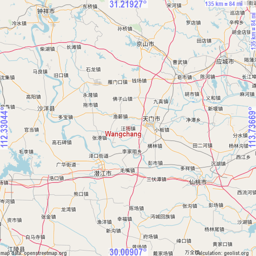
Wangchang GPS coordinates[2]
30° 36' 57.816" North, 113° 2' 0.816" East
| Map corner | latitude | longitude |
|---|---|---|
| Upper-left | 31.21927°, | 112.33044° |
| Center: | 30.61606°, | 113.03356° |
| Lower-right: | 30.00907°, | 113.73669° |
| Map W x H: | 134.6×134.6 km | = 83.6×83.6mi |
| max Lat: | 53.31946° ⇑48.7% North |
| Wangchang: | 30.61606° |
| min Lat: | ⇓51.3% South 18.22056° |
| min Long | Wangchang | max Long |
| 75.07348° | 113.03356° | 134.28917° |
| W 42.6%⇐ | ⇒57.4% E |
Elevation
Elevation of Wangchang is 31 m = 102 ft, and this is 453.8 m = 1489 ft below average elevation for this country.
| Max E: |
5622 m = 18445 ft | 77.7% |
| Avg. | 484.8 m = 1591 ft | |
| Wangchang | 31 m = 102 ft | |
Min E: |
-3 m = -10 ft | 22.3% |
See also: China elevation on elevation.city.
Geographical zone
Wangchang is located in North temperate zone (between Tropic of Cancer and the Arctic Circle). Distance of this Northern Tropic circle is 798.3 km =496 mi to South.| Distance of | km | miles | from Wangchang |
|---|---|---|---|
| North Pole | 6602.9 | 4102.9 | to North |
| Arctic Circle | 3997 | 2483.6 | to North |
| Tropic Cancer | 798.3 | 496 | to South |
| Equator | 3404.2 | 2115.3 | to South |


Nearby cities:
15 places around Wangchang: (largest is in red/bold)
• Fozishan
15.8 km =9.8 mi,  348°
348°
• Henglin
16.7 km =10.4 mi,  123°
123°
• Houkou
10.2 km =6.3 mi,  84°
84°
• Huangtan
7 km =4.3 mi,  44°
44°
• Jiangchang
9.6 km =6 mi,  265°
265°
• Jingling
7.4 km =4.6 mi,  59°
59°
• Jingling
12.6 km =7.8 mi,  73°
73°
• Lijiazui
12.2 km =7.6 mi,  170°
170°
• Shihe
16.4 km =10.2 mi,  15°
15°
• Tianmen
12.4 km =7.7 mi, 67°
• Xiaoban
17.6 km =10.9 mi,  91°
91°
• Yanglin
15 km =9.3 mi, 79°
• Yuxin
7.5 km =4.7 mi,  327°
327°
• Zhanggang
15.8 km =9.8 mi,  251°
251°
• Zhengchang
13.7 km =8.5 mi,  182°
182°
Sources, notices
• [Note1] Compared only with cities in China existing in our database
• [Src1] Map data: © OpenStreetMap contributors (CC-BY-SA)
• [Src2] Other city data from geonames.org with taken over terms of usage.
• [Src3] Geographical zone / Annual Mean Temperature by Robert A. Rohde @ Wikipedia
