Heyuan geodata
Heyuan (Guangdong) is a seat of a second-order administrative division; located in China in Asia/Shanghai (GMT+8) time zone. With population of 93,718 people, there are 451 cities with bigger population in this country. Compared to other cities in China, 91.2% of cities are located further ↑North; 52.5% of cities are located further ←West and 77.7% of cities have higher elevation than Heyuan. Note1


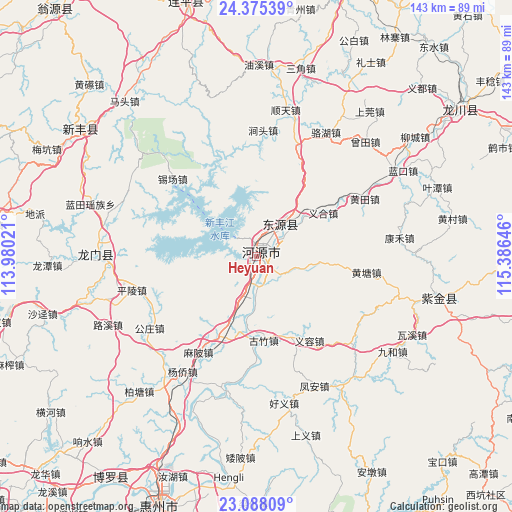
Heyuan GPS coordinates[2]
23° 43' 59.988" North, 114° 40' 59.988" East
| Map corner | latitude | longitude |
|---|---|---|
| Upper-left | 24.37539°, | 113.98021° |
| Center: | 23.73333°, | 114.68333° |
| Lower-right: | 23.08809°, | 115.38646° |
| Map W x H: | 143.1×143.1 km | = 88.9×88.9mi |
| max Lat: | 53.31946° ⇑91.2% North |
| Heyuan: | 23.73333° |
| min Lat: | ⇓8.8% South 18.22056° |
| min Long | Heyuan | max Long |
| 75.07348° | 114.68333° | 134.28917° |
| W 52.5%⇐ | ⇒47.5% E |
Elevation
Elevation of Heyuan is 31 m = 102 ft, and this is 453.8 m = 1489 ft below average elevation for this country.
| Max E: |
5622 m = 18445 ft | 77.7% |
| Avg. | 484.8 m = 1591 ft | |
| Heyuan | 31 m = 102 ft | |
Min E: |
-3 m = -10 ft | 22.3% |
See also: Heyuan elevation on elevation.city.
Geographical zone
Heyuan is located in North temperate zone (between Tropic of Cancer and the Arctic Circle). Distance of this Northern Tropic circle is 33 km =20.5 mi to South.| Distance of | km | miles | from Heyuan |
|---|---|---|---|
| North Pole | 7368.2 | 4578.4 | to North |
| Arctic Circle | 4762.3 | 2959.2 | to North |
| Tropic Cancer | 33 | 20.5 | to South |
| Equator | 2638.9 | 1639.7 | to South |


Nearby cities:
15 places around Heyuan: (largest is in red/bold)
• Baipu
17.3 km =10.7 mi,  98°
98°
• Dongpu
2.3 km =1.4 mi,  25°
25°
• Guzhu
24.3 km =15.1 mi,  174°
174°
• Jiushe
28.5 km =17.7 mi,  79°
79°
• Linjiang
9.2 km =5.7 mi, 173°
• Mabei
31.3 km =19.4 mi,  211°
211°
• Shangcheng
1.7 km =1.1 mi,  62°
62°
• Shiba
24.7 km =15.3 mi, 207°
• Shuangjiang
24.3 km =15.1 mi,  7°
7°
• Xiantang
13.4 km =8.3 mi,  40°
40°
• Xingang
7.1 km =4.4 mi,  319°
319°
• Xinhuilong
30.7 km =19.1 mi,  274°
274°
• Yihe
22.7 km =14.1 mi, 58°
• Yirong
27.8 km =17.3 mi,  147°
147°
• Yuannan
1.5 km =0.9 mi,  16°
16°
Sources, notices
• [Note1] Compared only with cities in China existing in our database
• [Src1] Map data: © OpenStreetMap contributors (CC-BY-SA)
• [Src2] Other city data from geonames.org with taken over terms of usage.
• [Src3] Geographical zone / Annual Mean Temperature by Robert A. Rohde @ Wikipedia
