Guzhu geodata
Guzhu (Guangdong) is a seat of a fourth-order administrative division; located in China in Asia/Shanghai (GMT+8) time zone. In our database, there are 1268 cities with bigger population. Compared to other cities in China, 92.1% of cities are located further ↑North; 52.7% of cities are located further ←West and 77.7% of cities have higher elevation than Guzhu. Note1


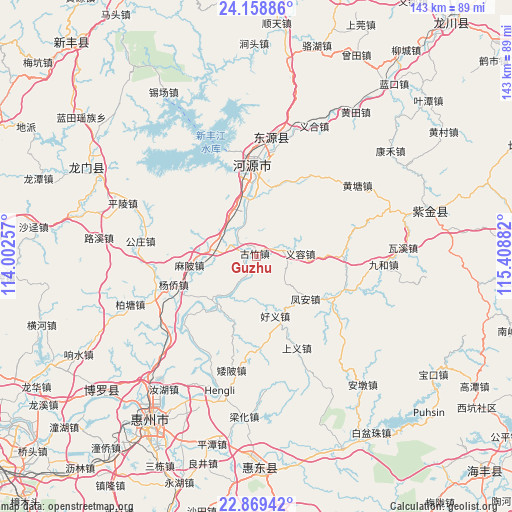
Guzhu GPS coordinates[2]
23° 30' 56.592" North, 114° 42' 20.484" East
| Map corner | latitude | longitude |
|---|---|---|
| Upper-left | 24.15886°, | 114.00257° |
| Center: | 23.51572°, | 114.70569° |
| Lower-right: | 22.86942°, | 115.40882° |
| Map W x H: | 143.4×143.4 km | = 89.1×89.1mi |
| max Lat: | 53.31946° ⇑92.1% North |
| Guzhu: | 23.51572° |
| min Lat: | ⇓7.9% South 18.22056° |
| min Long | Guzhu | max Long |
| 75.07348° | 114.70569° | 134.28917° |
| W 52.7%⇐ | ⇒47.3% E |
Elevation
Elevation of Guzhu is 31 m = 102 ft, and this is 453.8 m = 1489 ft below average elevation for this country.
| Max E: |
5622 m = 18445 ft | 77.7% |
| Avg. | 484.8 m = 1591 ft | |
| Guzhu | 31 m = 102 ft | |
Min E: |
-3 m = -10 ft | 22.3% |
See also: China elevation on elevation.city.
Geographical zone
Guzhu is located in North temperate zone (between Tropic of Cancer and the Arctic Circle). Distance of this Northern Tropic circle is 8.8 km =5.5 mi to South.| Distance of | km | miles | from Guzhu |
|---|---|---|---|
| North Pole | 7392.4 | 4593.4 | to North |
| Arctic Circle | 4786.5 | 2974.2 | to North |
| Tropic Cancer | 8.8 | 5.5 | to South |
| Equator | 2614.7 | 1624.7 | to South |


Nearby cities:
15 places around Guzhu: (largest is in red/bold)
• Feng’an
18.4 km =11.4 mi,  129°
129°
• Guanyinge
18.5 km =11.5 mi,  224°
224°
• Haoyi
16.9 km =10.5 mi,  162°
162°
• Heyuan
24.3 km =15.1 mi,  354°
354°
• Lantang
25.8 km =16 mi,  116°
116°
• Linjiang
15.1 km =9.4 mi,  355°
355°
• Luzhou
24.9 km =15.5 mi,  228°
228°
• Mabei
18.8 km =11.7 mi,  262°
262°
• Qingxi
25.4 km =15.8 mi,  84°
84°
• Shangcheng
25 km =15.5 mi, 358°
• Shiba
13.8 km =8.6 mi,  279°
279°
• Yangcun
25 km =15.5 mi,  249°
249°
• Yangqiao
24.4 km =15.2 mi, 251°
• Yirong
12.8 km =8 mi,  86°
86°
• Yuannan
25.7 km =16 mi, 355°
Sources, notices
• [Note1] Compared only with cities in China existing in our database
• [Src1] Map data: © OpenStreetMap contributors (CC-BY-SA)
• [Src2] Other city data from geonames.org with taken over terms of usage.
• [Src3] Geographical zone / Annual Mean Temperature by Robert A. Rohde @ Wikipedia
