Youzha geodata
Youzha (Yunnan) is a seat of a fourth-order administrative division; located in China in Asia/Shanghai (GMT+8) time zone. In our database, there are 1268 cities with bigger population. Compared to other cities in China, 88.6% of cities are located further ↑North; 91.2% of cities are located further →East and 94.7% of cities have lower elevation than Youzha. Note1


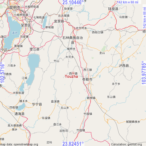
Youzha GPS coordinates[2]
24° 27' 57.996" North, 103° 16' 28.992" East
| Map corner | latitude | longitude |
|---|---|---|
| Upper-left | 25.10446°, | 102.5716° |
| Center: | 24.46611°, | 103.27472° |
| Lower-right: | 23.82451°, | 103.97785° |
| Map W x H: | 142.3×142.3 km | = 88.4×88.4mi |
| max Lat: | 53.31946° ⇑88.6% North |
| Youzha: | 24.46611° |
| min Lat: | ⇓11.4% South 18.22056° |
| min Long | Youzha | max Long |
| 75.07348° | 103.27472° | 134.28917° |
| W 8.8%⇐ | ⇒91.2% E |
Elevation
Elevation of Youzha is 1996 m = 6549 ft, and this is 1511.2 m = 4958 ft above average elevation for this country.
| Max E: |
5622 m = 18445 ft | 5.3% |
| Youzha | 1996 m 6549 ft | |
| Avg. | 484.8 m = 1591 ft | |
Min E: |
-3 m = -10 ft | 94.7% |
See also: China elevation on elevation.city.
Geographical zone
Youzha is located in North temperate zone (between Tropic of Cancer and the Arctic Circle). Distance of this Northern Tropic circle is 114.5 km =71.1 mi to South.| Distance of | km | miles | from Youzha |
|---|---|---|---|
| North Pole | 7286.7 | 4527.7 | to North |
| Arctic Circle | 4680.8 | 2908.5 | to North |
| Tropic Cancer | 114.5 | 71.1 | to South |
| Equator | 2720.4 | 1690.4 | to South |


Nearby cities:
15 places around Youzha: (largest is in red/bold)
• Dake
17 km =10.6 mi,  347°
347°
• Daxinshao
30.8 km =19.1 mi,  144°
144°
• Goujie
38.3 km =23.8 mi,  339°
339°
• Haikoudajie
33.8 km =21 mi,  281°
281°
• Hongxi
36 km =22.4 mi,  172°
172°
• Huakoulongtan
14.6 km =9.1 mi,  74°
74°
• Lufu
32.7 km =20.3 mi,  358°
358°
• Majie
24.5 km =15.2 mi, 356°
• Miyang
18.4 km =11.4 mi,  112°
112°
• Qinglong
29.7 km =18.5 mi,  264°
264°
• Qingnianlu
32.4 km =20.1 mi,  213°
213°
• Sijia
34.4 km =21.4 mi,  193°
193°
• Tonghong
25.1 km =15.6 mi,  235°
235°
• Weize
29.9 km =18.6 mi,  26°
26°
• Xilong
11.1 km =6.9 mi, 242°
Sources, notices
• [Note1] Compared only with cities in China existing in our database
• [Src1] Map data: © OpenStreetMap contributors (CC-BY-SA)
• [Src2] Other city data from geonames.org with taken over terms of usage.
• [Src3] Geographical zone / Annual Mean Temperature by Robert A. Rohde @ Wikipedia
