Weize geodata
Weize (Yunnan) is a seat of a fourth-order administrative division; located in China in Asia/Shanghai (GMT+8) time zone. In our database, there are 1268 cities with bigger population. Compared to other cities in China, 87.6% of cities are located further ↑North; 91% of cities are located further →East and 94.2% of cities have lower elevation than Weize. Note1


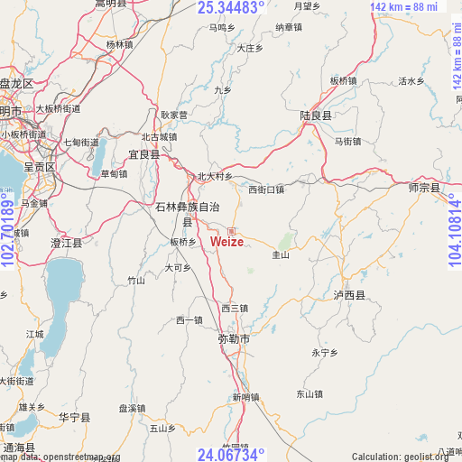
Weize GPS coordinates[2]
24° 42' 27.792" North, 103° 24' 18.036" East
| Map corner | latitude | longitude |
|---|---|---|
| Upper-left | 25.34483°, | 102.70189° |
| Center: | 24.70772°, | 103.40501° |
| Lower-right: | 24.06734°, | 104.10814° |
| Map W x H: | 142×142 km | = 88.2×88.2mi |
| max Lat: | 53.31946° ⇑87.6% North |
| Weize: | 24.70772° |
| min Lat: | ⇓12.4% South 18.22056° |
| min Long | Weize | max Long |
| 75.07348° | 103.40501° | 134.28917° |
| W 9%⇐ | ⇒91% E |
Elevation
Elevation of Weize is 1900 m = 6234 ft, and this is 1415.2 m = 4643 ft above average elevation for this country.
| Max E: |
5622 m = 18445 ft | 5.8% |
| Weize | 1900 m 6234 ft | |
| Avg. | 484.8 m = 1591 ft | |
Min E: |
-3 m = -10 ft | 94.2% |
See also: China elevation on elevation.city.
Geographical zone
Weize is located in North temperate zone (between Tropic of Cancer and the Arctic Circle). Distance of this Northern Tropic circle is 141.3 km =87.8 mi to South.| Distance of | km | miles | from Weize |
|---|---|---|---|
| North Pole | 7259.8 | 4511 | to North |
| Arctic Circle | 4653.9 | 2891.8 | to North |
| Tropic Cancer | 141.3 | 87.8 | to South |
| Equator | 2747.2 | 1707 | to South |


Nearby cities:
15 places around Weize: (largest is in red/bold)
• Beidacun Xiaozhai
17.3 km =10.7 mi,  344°
344°
• Beigucheng
38.2 km =23.7 mi,  323°
323°
• Caodianjie
40.1 km =24.9 mi,  297°
297°
• Dake
19.6 km =12.2 mi,  238°
238°
• Goujie
28.1 km =17.5 mi,  288°
288°
• Huakoulongtan
23 km =14.3 mi,  177°
177°
• Kuangyuan
34.6 km =21.5 mi,  311°
311°
• Lufu
15.2 km =9.4 mi, 292°
• Majie
15 km =9.3 mi,  260°
260°
• Miyang
34 km =21.1 mi,  173°
173°
• Nanyang
31.4 km =19.5 mi, 299°
• Shilin
14.4 km =8.9 mi,  329°
329°
• Suyang
35.5 km =22.1 mi, 310°
• Xilong
39.3 km =24.4 mi,  215°
215°
• Youzha
29.9 km =18.6 mi,  206°
206°
Sources, notices
• [Note1] Compared only with cities in China existing in our database
• [Src1] Map data: © OpenStreetMap contributors (CC-BY-SA)
• [Src2] Other city data from geonames.org with taken over terms of usage.
• [Src3] Geographical zone / Annual Mean Temperature by Robert A. Rohde @ Wikipedia
