Yongxing geodata
Yongxing (Hubei) is a seat of a fourth-order administrative division; located in China in Asia/Shanghai (GMT+8) time zone. In our database, there are 1268 cities with bigger population. Compared to other cities in China, 54.5% of cities are located further ↓South; 56.1% of cities are located further →East and 63.9% of cities have higher elevation than Yongxing. Note1


Yongxing GPS coordinates[2]
30° 57' 52.308" North, 113° 13' 50.412" East
| Map corner | latitude | longitude |
|---|---|---|
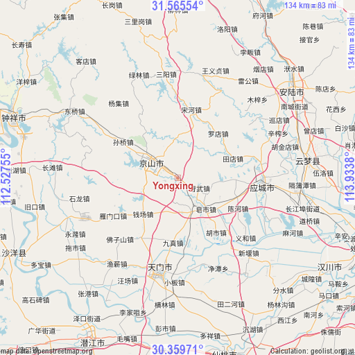
| Upper-left | 31.56554°, | 112.52755° |
| Center: | 30.96453°, | 113.23067° |
| Lower-right: | 30.35971°, | 113.9338° |
| Map W x H: | 134.1×134.1 km | = 83.3×83.3mi |
| max Lat: | 53.31946° ⇑45.5% North |
| Yongxing: | 30.96453° |
| min Lat: | ⇓54.5% South 18.22056° |
| min Long | Yongxing | max Long |
| 75.07348° | 113.23067° | 134.28917° |
| W 43.9%⇐ | ⇒56.1% E |
Elevation
Elevation of Yongxing is 78 m = 256 ft, and this is 406.8 m = 1335 ft below average elevation for this country.
| Max E: |
5622 m = 18445 ft | 63.9% |
| Avg. | 484.8 m = 1591 ft | |
| Yongxing | 78 m = 256 ft | |
Min E: |
-3 m = -10 ft | 36.1% |
See also: China elevation on elevation.city.
Geographical zone
Yongxing is located in North temperate zone (between Tropic of Cancer and the Arctic Circle). Distance of this Northern Tropic circle is 837 km =520.1 mi to South.| Distance of | km | miles | from Yongxing |
|---|---|---|---|
| North Pole | 6564.1 | 4078.7 | to North |
| Arctic Circle | 3958.2 | 2459.5 | to North |
| Tropic Cancer | 837 | 520.1 | to South |
| Equator | 3442.9 | 2139.3 | to South |


Nearby cities:
15 places around Yongxing: (largest is in red/bold)
• Caowu
10.7 km =6.6 mi,  86°
86°
• Chenhe
25.6 km =15.9 mi,  116°
116°
• Hushi
25.6 km =15.9 mi,  144°
144°
• Jiuzhen
24.2 km =15 mi,  183°
183°
• Liuhe
22 km =13.7 mi,  134°
134°
• Luodian
22.5 km =14 mi,  43°
43°
• Qianchang
19 km =11.8 mi,  223°
223°
• Sunqiao
24.7 km =15.3 mi,  303°
303°
• Tangchi
12.3 km =7.6 mi, 119°
• Tiandian
22 km =13.7 mi,  70°
70°
• Wufu
5.2 km =3.2 mi, 141°
• Xinshi
12.5 km =7.8 mi,  317°
317°
• Yangling
17.5 km =10.9 mi,  113°
113°
• Yihe
4.5 km =2.8 mi,  228°
228°
• Zaoshi
15.7 km =9.8 mi, 140°
Sources, notices
• [Note1] Compared only with cities in China existing in our database
• [Src1] Map data: © OpenStreetMap contributors (CC-BY-SA)
• [Src2] Other city data from geonames.org with taken over terms of usage.
• [Src3] Geographical zone / Annual Mean Temperature by Robert A. Rohde @ Wikipedia
