Luodian geodata
Luodian (Hubei) is a seat of a fourth-order administrative division; located in China in Asia/Shanghai (GMT+8) time zone. In our database, there are 1268 cities with bigger population. Compared to other cities in China, 55.6% of cities are located further ↓South; 55% of cities are located further →East and 69.2% of cities have higher elevation than Luodian. Note1


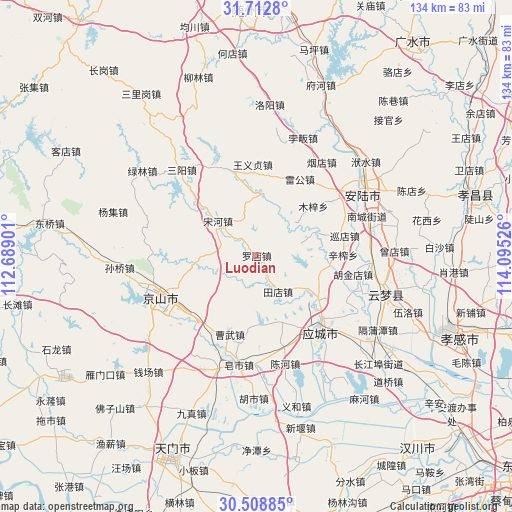
Luodian GPS coordinates[2]
31° 6' 45.828" North, 113° 23' 31.668" East
| Map corner | latitude | longitude |
|---|---|---|
| Upper-left | 31.7128°, | 112.68901° |
| Center: | 31.11273°, | 113.39213° |
| Lower-right: | 30.50885°, | 114.09526° |
| Map W x H: | 133.9×133.9 km | = 83.2×83.2mi |
| max Lat: | 53.31946° ⇑44.4% North |
| Luodian: | 31.11273° |
| min Lat: | ⇓55.6% South 18.22056° |
| min Long | Luodian | max Long |
| 75.07348° | 113.39213° | 134.28917° |
| W 45%⇐ | ⇒55% E |
Elevation
Elevation of Luodian is 55 m = 180 ft, and this is 429.8 m = 1410 ft below average elevation for this country.
| Max E: |
5622 m = 18445 ft | 69.2% |
| Avg. | 484.8 m = 1591 ft | |
| Luodian | 55 m = 180 ft | |
Min E: |
-3 m = -10 ft | 30.8% |
See also: China elevation on elevation.city.
Geographical zone
Luodian is located in North temperate zone (between Tropic of Cancer and the Arctic Circle). Distance of this Northern Tropic circle is 853.5 km =530.3 mi to South.| Distance of | km | miles | from Luodian |
|---|---|---|---|
| North Pole | 6547.7 | 4068.6 | to North |
| Arctic Circle | 3941.8 | 2449.3 | to North |
| Tropic Cancer | 853.5 | 530.3 | to South |
| Equator | 3459.4 | 2149.6 | to South |


Nearby cities:
15 places around Luodian: (largest is in red/bold)
• Caowu
16.4 km =10.2 mi,  196°
196°
• Chengbei
23.7 km =14.7 mi,  133°
133°
• Leigong
23.1 km =14.4 mi,  29°
29°
• Muzi
19.6 km =12.2 mi,  48°
48°
• Pingba
23.6 km =14.7 mi,  342°
342°
• Songhe
13.9 km =8.6 mi,  312°
312°
• Tangchi
23 km =14.3 mi,  191°
191°
• Tangdi
23.2 km =14.4 mi, 52°
• Tiandian
10.7 km =6.6 mi,  149°
149°
• Wufu
23.9 km =14.9 mi,  210°
210°
• Xinzha
22.6 km =14 mi,  88°
88°
• Xundian
23.6 km =14.7 mi,  76°
76°
• Yanghe
18.1 km =11.2 mi,  95°
95°
• Yangling
23.4 km =14.5 mi,  178°
178°
• Yongxing
22.5 km =14 mi,  223°
223°
Sources, notices
• [Note1] Compared only with cities in China existing in our database
• [Src1] Map data: © OpenStreetMap contributors (CC-BY-SA)
• [Src2] Other city data from geonames.org with taken over terms of usage.
• [Src3] Geographical zone / Annual Mean Temperature by Robert A. Rohde @ Wikipedia
