Sunqiao geodata
Sunqiao (Hubei) is a seat of a fourth-order administrative division; located in China in Asia/Shanghai (GMT+8) time zone. In our database, there are 1268 cities with bigger population. Compared to other cities in China, 55.5% of cities are located further ↓South; 57.5% of cities are located further →East and 57.4% of cities have higher elevation than Sunqiao. Note1


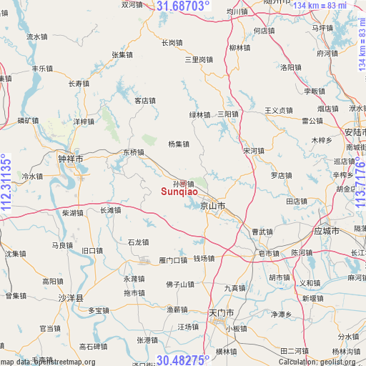
Sunqiao GPS coordinates[2]
31° 5' 12.48" North, 113° 0' 52.092" East
| Map corner | latitude | longitude |
|---|---|---|
| Upper-left | 31.68703°, | 112.31135° |
| Center: | 31.0868°, | 113.01447° |
| Lower-right: | 30.48275°, | 113.7176° |
| Map W x H: | 133.9×133.9 km | = 83.2×83.2mi |
| max Lat: | 53.31946° ⇑44.5% North |
| Sunqiao: | 31.0868° |
| min Lat: | ⇓55.5% South 18.22056° |
| min Long | Sunqiao | max Long |
| 75.07348° | 113.01447° | 134.28917° |
| W 42.5%⇐ | ⇒57.5% E |
Elevation
Elevation of Sunqiao is 115 m = 377 ft, and this is 369.8 m = 1213 ft below average elevation for this country.
| Max E: |
5622 m = 18445 ft | 57.4% |
| Avg. | 484.8 m = 1591 ft | |
| Sunqiao | 115 m = 377 ft | |
Min E: |
-3 m = -10 ft | 42.6% |
See also: China elevation on elevation.city.
Geographical zone
Sunqiao is located in North temperate zone (between Tropic of Cancer and the Arctic Circle). Distance of this Northern Tropic circle is 850.6 km =528.5 mi to South.| Distance of | km | miles | from Sunqiao |
|---|---|---|---|
| North Pole | 6550.5 | 4070.3 | to North |
| Arctic Circle | 3944.6 | 2451.1 | to North |
| Tropic Cancer | 850.6 | 528.5 | to South |
| Equator | 3456.5 | 2147.8 | to South |


Nearby cities:
15 places around Sunqiao: (largest is in red/bold)
• Caowu
33.8 km =21 mi,  112°
112°
• Changtan
28.4 km =17.6 mi,  250°
250°
• Dongqiao
21.1 km =13.1 mi,  304°
304°
• Kedian
33.5 km =20.8 mi,  335°
335°
• Lülin
25.9 km =16.1 mi,  13°
13°
• Qianchang
28.4 km =17.6 mi,  164°
164°
• Sanyang
30.2 km =18.8 mi,  32°
32°
• Shilong
26.9 km =16.7 mi,  217°
217°
• Songhe
28.4 km =17.6 mi,  64°
64°
• Wufu
29.6 km =18.4 mi,  126°
126°
• Xinshi
12.8 km =8 mi, 110°
• Yangji
14.8 km =9.2 mi,  352°
352°
• Yanmenkou
28.3 km =17.6 mi,  187°
187°
• Yihe
23.9 km =14.9 mi, 133°
• Yongxing
24.7 km =15.3 mi,  123°
123°
Sources, notices
• [Note1] Compared only with cities in China existing in our database
• [Src1] Map data: © OpenStreetMap contributors (CC-BY-SA)
• [Src2] Other city data from geonames.org with taken over terms of usage.
• [Src3] Geographical zone / Annual Mean Temperature by Robert A. Rohde @ Wikipedia
