Yongding geodata
Yongding (Yunnan) is a seat of a third-order administrative division; located in China in Asia/Shanghai (GMT+8) time zone. In our database, there are 1268 cities with bigger population. Compared to other cities in China, 82.2% of cities are located further ↑North; 93.2% of cities are located further →East and 91.5% of cities have lower elevation than Yongding. Note1


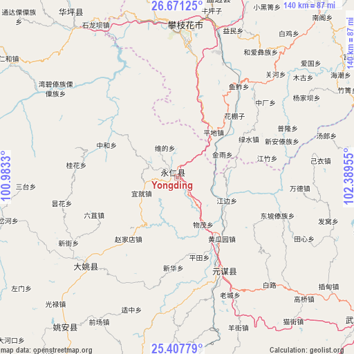
Yongding GPS coordinates[2]
26° 2' 28.392" North, 101° 41' 11.112" East
| Map corner | latitude | longitude |
|---|---|---|
| Upper-left | 26.67125°, | 100.9833° |
| Center: | 26.04122°, | 101.68642° |
| Lower-right: | 25.40779°, | 102.38955° |
| Map W x H: | 140.5×140.5 km | = 87.3×87.3mi |
| max Lat: | 53.31946° ⇑82.2% North |
| Yongding: | 26.04122° |
| min Lat: | ⇓17.8% South 18.22056° |
| min Long | Yongding | max Long |
| 75.07348° | 101.68642° | 134.28917° |
| W 6.8%⇐ | ⇒93.2% E |
Elevation
Elevation of Yongding is 1517 m = 4977 ft, and this is 1032.2 m = 3386 ft above average elevation for this country.
| Max E: |
5622 m = 18445 ft | 8.5% |
| Yongding | 1517 m 4977 ft | |
| Avg. | 484.8 m = 1591 ft | |
Min E: |
-3 m = -10 ft | 91.5% |
See also: China elevation on elevation.city.
Geographical zone
Yongding is located in North temperate zone (between Tropic of Cancer and the Arctic Circle). Distance of this Northern Tropic circle is 289.6 km =179.9 mi to South.| Distance of | km | miles | from Yongding |
|---|---|---|---|
| North Pole | 7111.5 | 4418.9 | to North |
| Arctic Circle | 4505.7 | 2799.7 | to North |
| Tropic Cancer | 289.6 | 179.9 | to South |
| Equator | 2895.5 | 1799.2 | to South |


Nearby cities:
15 places around Yongding: (largest is in red/bold)
• Dadukou
56.4 km =35 mi,  1°
1°
• Dongchuan
74.6 km =46.4 mi,  212°
212°
• Jiaoxiyakou
76.9 km =47.8 mi,  82°
82°
• Jinbi
50.9 km =31.6 mi,  223°
223°
• Laojiezi
88 km =54.7 mi, 82°
• Muzeng
79.2 km =49.2 mi,  89°
89°
• Panzhihua
60.5 km =37.6 mi, 2°
• Pujiawan
62.5 km =38.8 mi, 75°
• Qianjin
55.7 km =34.6 mi, 1°
• Renhe
51.2 km =31.8 mi,  5°
5°
• Tongzilin
75.1 km =46.7 mi, 12°
• Xiqu
63.4 km =39.4 mi,  352°
352°
• Yuanmou
41.5 km =25.8 mi,  153°
153°
• Yuquan
63.3 km =39.3 mi, 352°
• Zhongxin
76.2 km =47.3 mi,  327°
327°
Sources, notices
• [Note1] Compared only with cities in China existing in our database
• [Src1] Map data: © OpenStreetMap contributors (CC-BY-SA)
• [Src2] Other city data from geonames.org with taken over terms of usage.
• [Src3] Geographical zone / Annual Mean Temperature by Robert A. Rohde @ Wikipedia
