Muzeng geodata
Muzeng (Yunnan) is a seat of a fourth-order administrative division; located in China in Asia/Shanghai (GMT+8) time zone. In our database, there are 1268 cities with bigger population. Compared to other cities in China, 82.1% of cities are located further ↑North; 92.3% of cities are located further →East and 95.6% of cities have lower elevation than Muzeng. Note1


Muzeng GPS coordinates[2]
26° 3' 8.676" North, 102° 28' 45.372" East
| Map corner | latitude | longitude |
|---|---|---|
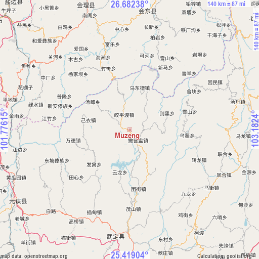
| Upper-left | 26.68238°, | 101.77615° |
| Center: | 26.05241°, | 102.47927° |
| Lower-right: | 25.41904°, | 103.1824° |
| Map W x H: | 140.5×140.5 km | = 87.3×87.3mi |
| max Lat: | 53.31946° ⇑82.1% North |
| Muzeng: | 26.05241° |
| min Lat: | ⇓17.9% South 18.22056° |
| min Long | Muzeng | max Long |
| 75.07348° | 102.47927° | 134.28917° |
| W 7.7%⇐ | ⇒92.3% E |
Elevation
Elevation of Muzeng is 2346 m = 7697 ft, and this is 1861.2 m = 6106 ft above average elevation for this country.
| Max E: |
5622 m = 18445 ft | 4.4% |
| Muzeng | 2346 m 7697 ft | |
| Avg. | 484.8 m = 1591 ft | |
Min E: |
-3 m = -10 ft | 95.6% |
See also: China elevation on elevation.city.
Geographical zone
Muzeng is located in North temperate zone (between Tropic of Cancer and the Arctic Circle). Distance of this Northern Tropic circle is 290.8 km =180.7 mi to South.| Distance of | km | miles | from Muzeng |
|---|---|---|---|
| North Pole | 7110.3 | 4418.1 | to North |
| Arctic Circle | 4504.4 | 2798.9 | to North |
| Tropic Cancer | 290.8 | 180.7 | to South |
| Equator | 2896.8 | 1800 | to South |


Nearby cities:
15 places around Muzeng: (largest is in red/bold)
• Chenggan
33.9 km =21.1 mi,  72°
72°
• Dianweijie
40.8 km =25.4 mi,  113°
113°
• Huidong
65.8 km =40.9 mi,  8°
8°
• Huili Chengguanzhen
71.8 km =44.6 mi,  340°
340°
• Jiaoxiyakou
8.9 km =5.5 mi, 340°
• Jincheng
61.8 km =38.4 mi,  187°
187°
• Kaji
31 km =19.3 mi,  94°
94°
• Laojie
81.3 km =50.5 mi,  44°
44°
• Laojiezi
13.4 km =8.3 mi, 36°
• Maoshanjie
42.8 km =26.6 mi,  177°
177°
• Pingshan
59.2 km =36.8 mi, 180°
• Pujiawan
23.9 km =14.9 mi,  308°
308°
• Xiaopingba
62.1 km =38.6 mi, 176°
• Yongding
79.2 km =49.2 mi,  269°
269°
• Yuanmou
72.2 km =44.9 mi,  237°
237°
Sources, notices
• [Note1] Compared only with cities in China existing in our database
• [Src1] Map data: © OpenStreetMap contributors (CC-BY-SA)
• [Src2] Other city data from geonames.org with taken over terms of usage.
• [Src3] Geographical zone / Annual Mean Temperature by Robert A. Rohde @ Wikipedia
