Pujiawan geodata
Pujiawan (Yunnan) is a seat of a fourth-order administrative division; located in China in Asia/Shanghai (GMT+8) time zone. In our database, there are 1268 cities with bigger population. Compared to other cities in China, 81.6% of cities are located further ↑North; 92.5% of cities are located further →East and 94.7% of cities have lower elevation than Pujiawan. Note1


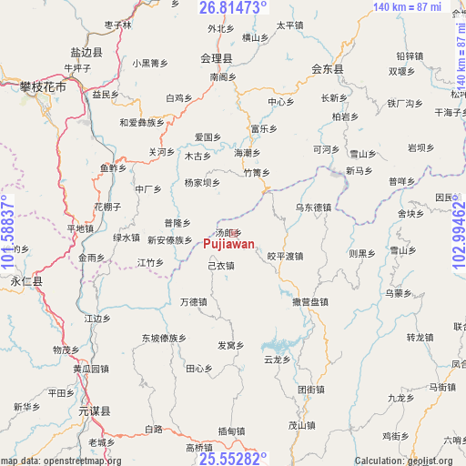
Pujiawan GPS coordinates[2]
26° 11' 7.728" North, 102° 17' 29.364" East
| Map corner | latitude | longitude |
|---|---|---|
| Upper-left | 26.81473°, | 101.58837° |
| Center: | 26.18548°, | 102.29149° |
| Lower-right: | 25.55282°, | 102.99462° |
| Map W x H: | 140.3×140.3 km | = 87.2×87.2mi |
| max Lat: | 53.31946° ⇑81.6% North |
| Pujiawan: | 26.18548° |
| min Lat: | ⇓18.4% South 18.22056° |
| min Long | Pujiawan | max Long |
| 75.07348° | 102.29149° | 134.28917° |
| W 7.5%⇐ | ⇒92.5% E |
Elevation
Elevation of Pujiawan is 2004 m = 6575 ft, and this is 1519.2 m = 4984 ft above average elevation for this country.
| Max E: |
5622 m = 18445 ft | 5.3% |
| Pujiawan | 2004 m 6575 ft | |
| Avg. | 484.8 m = 1591 ft | |
Min E: |
-3 m = -10 ft | 94.7% |
See also: China elevation on elevation.city.
Geographical zone
Pujiawan is located in North temperate zone (between Tropic of Cancer and the Arctic Circle). Distance of this Northern Tropic circle is 305.6 km =189.9 mi to South.| Distance of | km | miles | from Pujiawan |
|---|---|---|---|
| North Pole | 7095.5 | 4408.9 | to North |
| Arctic Circle | 4489.6 | 2789.7 | to North |
| Tropic Cancer | 305.6 | 189.9 | to South |
| Equator | 2911.6 | 1809.2 | to South |


Nearby cities:
15 places around Pujiawan: (largest is in red/bold)
• Chenggan
51.2 km =31.8 mi,  94°
94°
• Dadukou
70.9 km =44.1 mi,  304°
304°
• Dianweijie
64.2 km =39.9 mi,  118°
118°
• Huidong
57.7 km =35.9 mi,  29°
29°
• Huili Chengguanzhen
53.3 km =33.1 mi,  354°
354°
• Jiaoxiyakou
17.1 km =10.6 mi,  111°
111°
• Kaji
52.6 km =32.7 mi, 109°
• Laojiezi
27 km =16.8 mi,  98°
98°
• Maoshanjie
61.2 km =38 mi,  160°
160°
• Muzeng
23.9 km =14.9 mi,  128°
128°
• Qianjin
71.3 km =44.3 mi, 303°
• Renhe
65.2 km =40.5 mi, 302°
• Tongzilin
72.1 km =44.8 mi,  322°
322°
• Yongding
62.5 km =38.8 mi,  255°
255°
• Yuanmou
68 km =42.3 mi,  218°
218°
Sources, notices
• [Note1] Compared only with cities in China existing in our database
• [Src1] Map data: © OpenStreetMap contributors (CC-BY-SA)
• [Src2] Other city data from geonames.org with taken over terms of usage.
• [Src3] Geographical zone / Annual Mean Temperature by Robert A. Rohde @ Wikipedia
