Sandu geodata
Sandu (Jiangxi) is a seat of a fourth-order administrative division; located in China in Asia/Shanghai (GMT+8) time zone. In our database, there are 1268 cities with bigger population. Compared to other cities in China, 63.5% of cities are located further ↑North; 52.5% of cities are located further ←West and 62.9% of cities have higher elevation than Sandu. Note1


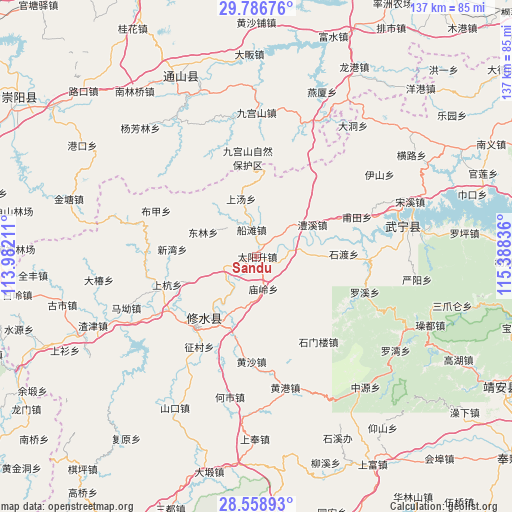
Sandu GPS coordinates[2]
29° 10' 28.848" North, 114° 41' 6.828" East
| Map corner | latitude | longitude |
|---|---|---|
| Upper-left | 29.78676°, | 113.98211° |
| Center: | 29.17468°, | 114.68523° |
| Lower-right: | 28.55893°, | 115.38836° |
| Map W x H: | 136.5×136.5 km | = 84.8×84.8mi |
| max Lat: | 53.31946° ⇑63.5% North |
| Sandu: | 29.17468° |
| min Lat: | ⇓36.5% South 18.22056° |
| min Long | Sandu | max Long |
| 75.07348° | 114.68523° | 134.28917° |
| W 52.5%⇐ | ⇒47.5% E |
Elevation
Elevation of Sandu is 83 m = 272 ft, and this is 401.8 m = 1318 ft below average elevation for this country.
| Max E: |
5622 m = 18445 ft | 62.9% |
| Avg. | 484.8 m = 1591 ft | |
| Sandu | 83 m = 272 ft | |
Min E: |
-3 m = -10 ft | 37.1% |
See also: China elevation on elevation.city.
Geographical zone
Sandu is located in North temperate zone (between Tropic of Cancer and the Arctic Circle). Distance of this Northern Tropic circle is 638 km =396.4 mi to South.| Distance of | km | miles | from Sandu |
|---|---|---|---|
| North Pole | 6763.1 | 4202.4 | to North |
| Arctic Circle | 4157.3 | 2583.2 | to North |
| Tropic Cancer | 638 | 396.4 | to South |
| Equator | 3243.9 | 2015.7 | to South |


Nearby cities:
15 places around Sandu: (largest is in red/bold)
• Chuantan
7.3 km =4.5 mi,  349°
349°
• Donglin
15.7 km =9.8 mi,  294°
294°
• Hangkou
27.6 km =17.1 mi,  239°
239°
• Huang’ao
24.7 km =15.3 mi,  151°
151°
• Lixi
17 km =10.6 mi,  61°
61°
• Miaoling
8 km =5 mi,  166°
166°
• Qingjiang
10.1 km =6.3 mi,  78°
78°
• Shanghang
25.2 km =15.7 mi,  252°
252°
• Shangtang
16 km =9.9 mi,  344°
344°
• Shidu
24.3 km =15.1 mi, 80°
• Shimenlou
28 km =17.4 mi,  144°
144°
• Sidu
9.6 km =6 mi, 254°
• Xinwan
22.6 km =14 mi,  275°
275°
• Yining
19.4 km =12.1 mi,  217°
217°
• Zhuping
27.3 km =17 mi,  228°
228°
Sources, notices
• [Note1] Compared only with cities in China existing in our database
• [Src1] Map data: © OpenStreetMap contributors (CC-BY-SA)
• [Src2] Other city data from geonames.org with taken over terms of usage.
• [Src3] Geographical zone / Annual Mean Temperature by Robert A. Rohde @ Wikipedia
