Yingli geodata
Yingli (Guangdong) is a seat of a fourth-order administrative division; located in China in Asia/Urumqi (GMT+6) time zone. In our database, there are 1268 cities with bigger population. Compared to other cities in China, 98.6% of cities are located further ↑North; 70.8% of cities are located further →East and 55.7% of cities have higher elevation than Yingli. Note1


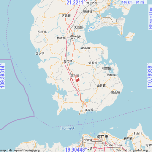
Yingli GPS coordinates[2]
20° 33' 51.156" North, 110° 5' 46.536" East
| Map corner | latitude | longitude |
|---|---|---|
| Upper-left | 21.2211°, | 109.39314° |
| Center: | 20.56421°, | 110.09626° |
| Lower-right: | 19.90448°, | 110.79939° |
| Map W x H: | 146.4×146.4 km | = 91×91mi |
| max Lat: | 53.31946° ⇑98.6% North |
| Yingli: | 20.56421° |
| min Lat: | ⇓1.4% South 18.22056° |
| min Long | Yingli | max Long |
| 75.07348° | 110.09626° | 134.28917° |
| W 29.2%⇐ | ⇒70.8% E |
Elevation
Elevation of Yingli is 126 m = 413 ft, and this is 358.8 m = 1177 ft below average elevation for this country.
| Max E: |
5622 m = 18445 ft | 55.7% |
| Avg. | 484.8 m = 1591 ft | |
| Yingli | 126 m = 413 ft | |
Min E: |
-3 m = -10 ft | 44.3% |
See also: China elevation on elevation.city.
Geographical zone
Yingli is located in North Torrid zone (between Equator and Tropic of Cancer). Distance of this Northern Tropic circle is 319.4 km =198.5 mi to North.| Distance of | km | miles | from Yingli |
|---|---|---|---|
| North Pole | 7720.5 | 4797.3 | to North |
| Arctic Circle | 5114.6 | 3178.1 | to North |
| Tropic Cancer | 319.4 | 198.5 | to North |
| Equator | 2286.5 | 1420.8 | to South |


Nearby cities:
15 places around Yingli: (largest is in red/bold)
• Beihe
24.8 km =15.4 mi,  293°
293°
• Chengbei
28 km =17.4 mi,  162°
162°
• He’an
29.4 km =18.3 mi,  75°
75°
• Leigao
29.1 km =18.1 mi,  20°
20°
• Longmen
17.5 km =10.9 mi,  339°
339°
• Maichen
27.6 km =17.1 mi,  202°
202°
• Nanshan
28.9 km =18 mi,  165°
165°
• Nanxing
26.6 km =16.5 mi,  359°
359°
• Qujie
25.4 km =15.8 mi,  110°
110°
• Tandou
21.3 km =13.2 mi,  258°
258°
• Tiaofeng
21.1 km =13.1 mi,  50°
50°
• Wushi
24 km =14.9 mi,  267°
267°
• Xiaqiao
13.4 km =8.3 mi, 163°
• Xilian
25.8 km =16 mi,  217°
217°
• Xucheng
27.2 km =16.9 mi, 164°
Sources, notices
• [Note1] Compared only with cities in China existing in our database
• [Src1] Map data: © OpenStreetMap contributors (CC-BY-SA)
• [Src2] Other city data from geonames.org with taken over terms of usage.
• [Src3] Geographical zone / Annual Mean Temperature by Robert A. Rohde @ Wikipedia
