Xilian geodata
Xilian (Guangdong) is a seat of a fourth-order administrative division; located in China in Asia/Urumqi (GMT+6) time zone. In our database, there are 1268 cities with bigger population. Compared to other cities in China, 98.6% of cities are located further ↑North; 71.5% of cities are located further →East and 82.9% of cities have higher elevation than Xilian. Note1


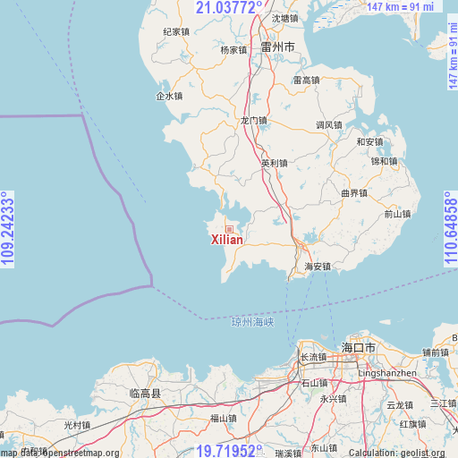
Xilian GPS coordinates[2]
20° 22' 48.108" North, 109° 56' 43.62" East
| Map corner | latitude | longitude |
|---|---|---|
| Upper-left | 21.03772°, | 109.24233° |
| Center: | 20.38003°, | 109.94545° |
| Lower-right: | 19.71952°, | 110.64858° |
| Map W x H: | 146.6×146.6 km | = 91.1×91.1mi |
| max Lat: | 53.31946° ⇑98.6% North |
| Xilian: | 20.38003° |
| min Lat: | ⇓1.4% South 18.22056° |
| min Long | Xilian | max Long |
| 75.07348° | 109.94545° | 134.28917° |
| W 28.5%⇐ | ⇒71.5% E |
Elevation
Elevation of Xilian is 20 m = 66 ft, and this is 464.8 m = 1525 ft below average elevation for this country.
| Max E: |
5622 m = 18445 ft | 82.9% |
| Avg. | 484.8 m = 1591 ft | |
| Xilian | 20 m = 66 ft | |
Min E: |
-3 m = -10 ft | 17.1% |
See also: China elevation on elevation.city.
Geographical zone
Xilian is located in North Torrid zone (between Equator and Tropic of Cancer). Distance of this Northern Tropic circle is 339.9 km =211.2 mi to North.| Distance of | km | miles | from Xilian |
|---|---|---|---|
| North Pole | 7741 | 4810 | to North |
| Arctic Circle | 5135.1 | 3190.8 | to North |
| Tropic Cancer | 339.9 | 211.2 | to North |
| Equator | 2266 | 1408 | to South |


Nearby cities:
15 places around Xilian: (largest is in red/bold)
• Beihe
31.2 km =19.4 mi,  346°
346°
• Chengbei
25 km =15.5 mi,  104°
104°
• Hai’an
31.6 km =19.6 mi,  110°
110°
• Jiaoweixiang
12.5 km =7.8 mi,  172°
172°
• Longmen
38 km =23.6 mi,  14°
14°
• Longtang
41.9 km =26 mi, 98°
• Maichen
7.2 km =4.5 mi,  134°
134°
• Nanshan
24 km =14.9 mi, 108°
• Qishui
45.1 km =28 mi,  337°
337°
• Qujie
41.3 km =25.7 mi,  73°
73°
• Tandou
17.1 km =10.6 mi, 342°
• Wushi
20.9 km =13 mi, 336°
• Xiaqiao
20.9 km =13 mi, 68°
• Xucheng
23.8 km =14.8 mi, 103°
• Yingli
25.8 km =16 mi,  37°
37°
Sources, notices
• [Note1] Compared only with cities in China existing in our database
• [Src1] Map data: © OpenStreetMap contributors (CC-BY-SA)
• [Src2] Other city data from geonames.org with taken over terms of usage.
• [Src3] Geographical zone / Annual Mean Temperature by Robert A. Rohde @ Wikipedia
