Xucheng geodata
Xucheng (Guangdong) is a seat of a third-order administrative division; located in China in Asia/Urumqi (GMT+6) time zone. With population of 83,267 people, there are 509 cities with bigger population in this country. Compared to other cities in China, 98.7% of cities are located further ↑North; 70.5% of cities are located further →East and 64.5% of cities have higher elevation than Xucheng. Note1


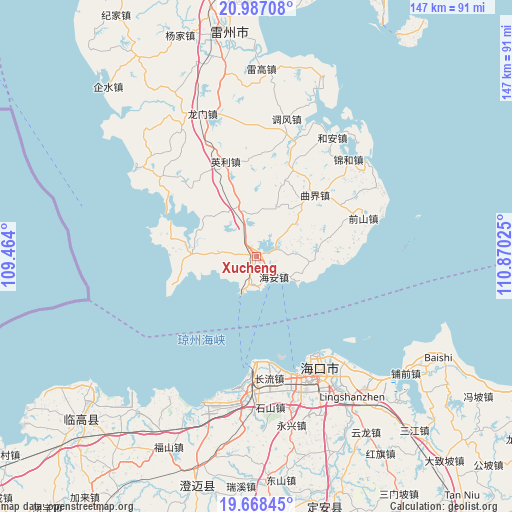
Xucheng GPS coordinates[2]
20° 19' 45.012" North, 110° 10' 1.632" East
| Map corner | latitude | longitude |
|---|---|---|
| Upper-left | 20.98708°, | 109.464° |
| Center: | 20.32917°, | 110.16712° |
| Lower-right: | 19.66845°, | 110.87025° |
| Map W x H: | 146.6×146.6 km | = 91.1×91.1mi |
| max Lat: | 53.31946° ⇑98.7% North |
| Xucheng: | 20.32917° |
| min Lat: | ⇓1.3% South 18.22056° |
| min Long | Xucheng | max Long |
| 75.07348° | 110.16712° | 134.28917° |
| W 29.5%⇐ | ⇒70.5% E |
Elevation
Elevation of Xucheng is 75 m = 246 ft, and this is 409.8 m = 1344 ft below average elevation for this country.
| Max E: |
5622 m = 18445 ft | 64.5% |
| Avg. | 484.8 m = 1591 ft | |
| Xucheng | 75 m = 246 ft | |
Min E: |
-3 m = -10 ft | 35.5% |
See also: Xucheng elevation on elevation.city.
Geographical zone
Xucheng is located in North Torrid zone (between Equator and Tropic of Cancer). Distance of this Northern Tropic circle is 345.5 km =214.7 mi to North.| Distance of | km | miles | from Xucheng |
|---|---|---|---|
| North Pole | 7746.7 | 4813.6 | to North |
| Arctic Circle | 5140.8 | 3194.3 | to North |
| Tropic Cancer | 345.5 | 214.7 | to North |
| Equator | 2260.4 | 1404.5 | to South |


Nearby cities:
15 places around Xucheng: (largest is in red/bold)
• Changliu
35.3 km =21.9 mi,  174°
174°
• Chengbei
1.3 km =0.8 mi,  113°
113°
• Haikou
36.4 km =22.6 mi,  149°
149°
• Hai’an
8.5 km =5.3 mi,  130°
130°
• Jiaoweixiang
22.5 km =14 mi,  252°
252°
• Jinhe
37 km =23 mi,  43°
43°
• Longtang
18.3 km =11.4 mi,  92°
92°
• Maichen
18 km =11.2 mi,  272°
272°
• Nanshan
1.9 km =1.2 mi,  188°
188°
• Qianshan
32.5 km =20.2 mi,  70°
70°
• Qujie
24 km =14.9 mi, 43°
• Tandou
35.8 km =22.2 mi,  307°
307°
• Xiaqiao
13.7 km =8.5 mi,  344°
344°
• Xilian
23.8 km =14.8 mi,  283°
283°
• Yingli
27.2 km =16.9 mi, 344°
Sources, notices
• [Note1] Compared only with cities in China existing in our database
• [Src1] Map data: © OpenStreetMap contributors (CC-BY-SA)
• [Src2] Other city data from geonames.org with taken over terms of usage.
• [Src3] Geographical zone / Annual Mean Temperature by Robert A. Rohde @ Wikipedia
