He’an geodata
He’an (Guangdong) is a seat of a fourth-order administrative division; located in China in Asia/Urumqi (GMT+6) time zone. In our database, there are 1268 cities with bigger population. Compared to other cities in China, 98.6% of cities are located further ↑North; 69.6% of cities are located further →East and 99.9% of cities have higher elevation than He’an. Note1


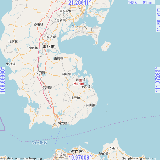
He’an GPS coordinates[2]
20° 37' 46.236" North, 110° 22' 11.28" East
| Map corner | latitude | longitude |
|---|---|---|
| Upper-left | 21.28611°, | 109.66668° |
| Center: | 20.62951°, | 110.3698° |
| Lower-right: | 19.97006°, | 111.07293° |
| Map W x H: | 146.3×146.3 km | = 90.9×90.9mi |
| max Lat: | 53.31946° ⇑98.6% North |
| He’an: | 20.62951° |
| min Lat: | ⇓1.4% South 18.22056° |
| min Long | He’an | max Long |
| 75.07348° | 110.3698° | 134.28917° |
| W 30.4%⇐ | ⇒69.6% E |
Elevation
Elevation of He’an is 0 m = 0 ft, and this is 484.8 m = 1591 ft below average elevation for this country.
| Max E: |
5622 m = 18445 ft | 99.9% |
| Avg. | 484.8 m = 1591 ft | |
| He’an | 0 m = 0 ft | |
Min E: |
-3 m = -10 ft | 0.1% |
See also: China elevation on elevation.city.
Geographical zone
He’an is located in North Torrid zone (between Equator and Tropic of Cancer). Distance of this Northern Tropic circle is 312.1 km =193.9 mi to North.| Distance of | km | miles | from He’an |
|---|---|---|---|
| North Pole | 7713.3 | 4792.8 | to North |
| Arctic Circle | 5107.4 | 3173.6 | to North |
| Tropic Cancer | 312.1 | 193.9 | to North |
| Equator | 2293.8 | 1425.3 | to South |


Nearby cities:
15 places around He’an: (largest is in red/bold)
• Chengbei
39.3 km =24.4 mi,  210°
210°
• Dongli
18.1 km =11.2 mi,  357°
357°
• Jinhe
7.8 km =4.8 mi,  146°
146°
• Leigao
27.1 km =16.8 mi,  317°
317°
• Longmen
35.8 km =22.2 mi,  284°
284°
• Longtang
34.4 km =21.4 mi,  184°
184°
• Nanxing
34.6 km =21.5 mi,  304°
304°
• Qianshan
24.5 km =15.2 mi,  157°
157°
• Qujie
16.7 km =10.4 mi,  196°
196°
• Tiaofeng
13.8 km =8.6 mi, 297°
• Xiaqiao
31.9 km =19.8 mi,  230°
230°
• Xiayang
19 km =11.8 mi,  133°
133°
• Xinliao
9.8 km =6.1 mi,  95°
95°
• Xucheng
39.5 km =24.5 mi, 212°
• Yingli
29.4 km =18.3 mi,  255°
255°
Sources, notices
• [Note1] Compared only with cities in China existing in our database
• [Src1] Map data: © OpenStreetMap contributors (CC-BY-SA)
• [Src2] Other city data from geonames.org with taken over terms of usage.
• [Src3] Geographical zone / Annual Mean Temperature by Robert A. Rohde @ Wikipedia
