Nanshan geodata
Nanshan (Guangdong) is a seat of a fourth-order administrative division; located in China in Asia/Urumqi (GMT+6) time zone. In our database, there are 1268 cities with bigger population. Compared to other cities in China, 98.7% of cities are located further ↑North; 70.5% of cities are located further →East and 66.4% of cities have higher elevation than Nanshan. Note1


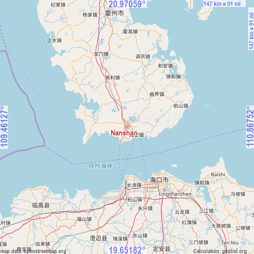
Nanshan GPS coordinates[2]
20° 18' 45.396" North, 110° 9' 51.804" East
| Map corner | latitude | longitude |
|---|---|---|
| Upper-left | 20.97059°, | 109.46127° |
| Center: | 20.31261°, | 110.16439° |
| Lower-right: | 19.65182°, | 110.86752° |
| Map W x H: | 146.6×146.6 km | = 91.1×91.1mi |
| max Lat: | 53.31946° ⇑98.7% North |
| Nanshan: | 20.31261° |
| min Lat: | ⇓1.3% South 18.22056° |
| min Long | Nanshan | max Long |
| 75.07348° | 110.16439° | 134.28917° |
| W 29.5%⇐ | ⇒70.5% E |
Elevation
Elevation of Nanshan is 67 m = 220 ft, and this is 417.8 m = 1371 ft below average elevation for this country.
| Max E: |
5622 m = 18445 ft | 66.4% |
| Avg. | 484.8 m = 1591 ft | |
| Nanshan | 67 m = 220 ft | |
Min E: |
-3 m = -10 ft | 33.6% |
See also: China elevation on elevation.city.
Geographical zone
Nanshan is located in North Torrid zone (between Equator and Tropic of Cancer). Distance of this Northern Tropic circle is 347.4 km =215.9 mi to North.| Distance of | km | miles | from Nanshan |
|---|---|---|---|
| North Pole | 7748.5 | 4814.7 | to North |
| Arctic Circle | 5142.6 | 3195.5 | to North |
| Tropic Cancer | 347.4 | 215.9 | to North |
| Equator | 2258.6 | 1403.4 | to South |


Nearby cities:
15 places around Nanshan: (largest is in red/bold)
• Changliu
33.5 km =20.8 mi,  173°
173°
• Chengbei
2 km =1.2 mi,  47°
47°
• Haikou
35 km =21.7 mi,  148°
148°
• Haixiu
35.5 km =22.1 mi,  160°
160°
• Hai’an
7.7 km =4.8 mi,  118°
118°
• Jiaoweixiang
21.8 km =13.5 mi,  256°
256°
• Longtang
18.6 km =11.6 mi,  87°
87°
• Maichen
17.9 km =11.1 mi,  278°
278°
• Qianshan
33.4 km =20.8 mi,  67°
67°
• Qujie
25.5 km =15.8 mi,  41°
41°
• Tandou
36.8 km =22.9 mi,  310°
310°
• Xiaqiao
15.5 km =9.6 mi,  347°
347°
• Xilian
24 km =14.9 mi,  288°
288°
• Xucheng
1.9 km =1.2 mi,  8°
8°
• Yingli
28.9 km =18 mi, 345°
Sources, notices
• [Note1] Compared only with cities in China existing in our database
• [Src1] Map data: © OpenStreetMap contributors (CC-BY-SA)
• [Src2] Other city data from geonames.org with taken over terms of usage.
• [Src3] Geographical zone / Annual Mean Temperature by Robert A. Rohde @ Wikipedia
