Baixi geodata
Baixi (Sichuan) is a seat of a third-order administrative division; located in China in Asia/Shanghai (GMT+8) time zone. In our database, there are 1268 cities with bigger population. Compared to other cities in China, 68% of cities are located further ↑North; 89.6% of cities are located further →East and 63% of cities have lower elevation than Baixi. Note1


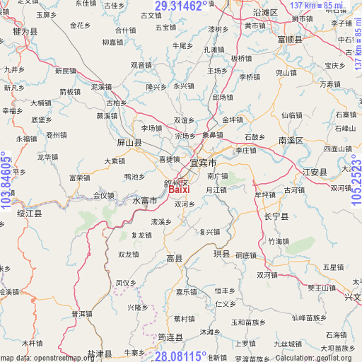
Baixi GPS coordinates[2]
28° 41' 58.92" North, 104° 32' 57.012" East
| Map corner | latitude | longitude |
|---|---|---|
| Upper-left | 29.31462°, | 103.84605° |
| Center: | 28.6997°, | 104.54917° |
| Lower-right: | 28.08115°, | 105.2523° |
| Map W x H: | 137.1×137.2 km | = 85.2×85.3mi |
| max Lat: | 53.31946° ⇑68% North |
| Baixi: | 28.6997° |
| min Lat: | ⇓32% South 18.22056° |
| min Long | Baixi | max Long |
| 75.07348° | 104.54917° | 134.28917° |
| W 10.4%⇐ | ⇒89.6% E |
Elevation
Elevation of Baixi is 296 m = 971 ft, and this is 188.8 m = 619 ft below average elevation for this country.
| Max E: |
5622 m = 18445 ft | 37% |
| Avg. | 484.8 m = 1591 ft | |
| Baixi | 296 m = 971 ft | |
Min E: |
-3 m = -10 ft | 63% |
See also: China elevation on elevation.city.
Geographical zone
Baixi is located in North temperate zone (between Tropic of Cancer and the Arctic Circle). Distance of this Northern Tropic circle is 585.2 km =363.6 mi to South.| Distance of | km | miles | from Baixi |
|---|---|---|---|
| North Pole | 6816 | 4235.3 | to North |
| Arctic Circle | 4210.1 | 2616 | to North |
| Tropic Cancer | 585.2 | 363.6 | to South |
| Equator | 3191.1 | 1982.9 | to South |


Nearby cities:
15 places around Baixi: (largest is in red/bold)
• Changning
38.7 km =24 mi,  110°
110°
• Chuansiba
58.9 km =36.6 mi,  224°
224°
• Huiyi
33.7 km =20.9 mi,  254°
254°
• Jiang’an
50.8 km =31.6 mi,  85°
85°
• Junlian
58.9 km =36.6 mi,  183°
183°
• Nanxi
44.8 km =27.8 mi,  69°
69°
• Qingfu
29.4 km =18.3 mi,  186°
186°
• Taipingdian
35.5 km =22.1 mi,  243°
243°
• Tantou
53.9 km =33.5 mi,  210°
210°
• Tantouchang
50.5 km =31.4 mi, 210°
• Xiangjiaba
16 km =9.9 mi, 242°
• Xinfa
26.6 km =16.5 mi,  303°
303°
• Xinglongchang
50.7 km =31.5 mi,  197°
197°
• Xunchang
31.7 km =19.7 mi,  149°
149°
• Yibin
10.4 km =6.5 mi,  44°
44°
Sources, notices
• [Note1] Compared only with cities in China existing in our database
• [Src1] Map data: © OpenStreetMap contributors (CC-BY-SA)
• [Src2] Other city data from geonames.org with taken over terms of usage.
• [Src3] Geographical zone / Annual Mean Temperature by Robert A. Rohde @ Wikipedia
