Yangshuo geodata
Yangshuo (Guangxi) is a populated place(s); located in China in Asia/Shanghai (GMT+8) time zone. With population of 300,000 people, there are 179 cities with bigger population in this country. Compared to other cities in China, 87.3% of cities are located further ↑North; 69.1% of cities are located further →East and 57.2% of cities have higher elevation than Yangshuo. Note1


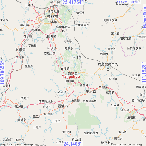
Yangshuo GPS coordinates[2]
24° 46' 50.916" North, 110° 29' 22.812" East
| Map corner | latitude | longitude |
|---|---|---|
| Upper-left | 25.41754°, | 109.78655° |
| Center: | 24.78081°, | 110.48967° |
| Lower-right: | 24.1408°, | 111.1928° |
| Map W x H: | 142×142 km | = 88.2×88.2mi |
| max Lat: | 53.31946° ⇑87.3% North |
| Yangshuo: | 24.78081° |
| min Lat: | ⇓12.7% South 18.22056° |
| min Long | Yangshuo | max Long |
| 75.07348° | 110.48967° | 134.28917° |
| W 30.9%⇐ | ⇒69.1% E |
Elevation
Elevation of Yangshuo is 116 m = 381 ft, and this is 368.8 m = 1210 ft below average elevation for this country.
| Max E: |
5622 m = 18445 ft | 57.2% |
| Avg. | 484.8 m = 1591 ft | |
| Yangshuo | 116 m = 381 ft | |
Min E: |
-3 m = -10 ft | 42.8% |
See also: Yangshuo elevation on elevation.city.
Geographical zone
Yangshuo is located in North temperate zone (between Tropic of Cancer and the Arctic Circle). Distance of this Northern Tropic circle is 149.4 km =92.8 mi to South.| Distance of | km | miles | from Yangshuo |
|---|---|---|---|
| North Pole | 7251.7 | 4506 | to North |
| Arctic Circle | 4645.8 | 2886.8 | to North |
| Tropic Cancer | 149.4 | 92.8 | to South |
| Equator | 2755.4 | 1712.1 | to South |


Nearby cities:
15 places around Yangshuo: (largest is in red/bold)
• Fuyang
77.8 km =48.3 mi,  85°
85°
• Gongcheng
33.5 km =20.8 mi,  79°
79°
• Guilin
59.4 km =36.9 mi,  339°
339°
• Jinxiu
78.1 km =48.5 mi,  203°
203°
• Lanxi
75.9 km =47.2 mi,  62°
62°
• Licheng
32.1 km =19.9 mi, 198°
• Lingchuan
71.9 km =44.7 mi,  346°
346°
• Luzhai
82.7 km =51.4 mi,  247°
247°
• Mengshan
63.1 km =39.2 mi,  177°
177°
• Pingle
21.6 km =13.4 mi,  134°
134°
• Xing’an
94.5 km =58.7 mi,  9°
9°
• Yongfu
56.9 km =35.4 mi,  295°
295°
• Yuankou
62.1 km =38.6 mi,  66°
66°
• Zhaoping
74 km =46 mi,  156°
156°
• Zhongshan
86.4 km =53.7 mi,  108°
108°
Sources, notices
• [Note1] Compared only with cities in China existing in our database
• [Src1] Map data: © OpenStreetMap contributors (CC-BY-SA)
• [Src2] Other city data from geonames.org with taken over terms of usage.
• [Src3] Geographical zone / Annual Mean Temperature by Robert A. Rohde @ Wikipedia
