Yongfu geodata
Yongfu (Guangxi) is a seat of a third-order administrative division; located in China in Asia/Shanghai (GMT+8) time zone. In our database, there are 1268 cities with bigger population. Compared to other cities in China, 86.3% of cities are located further ↑North; 71.3% of cities are located further →East and 54.8% of cities have lower elevation than Yongfu. Note1


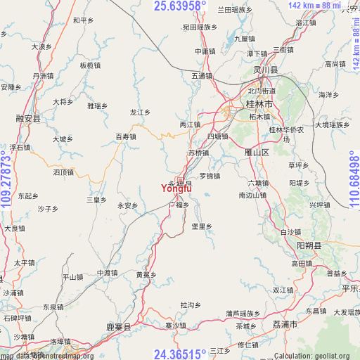
Yongfu GPS coordinates[2]
25° 0' 14.472" North, 109° 58' 54.66" East
| Map corner | latitude | longitude |
|---|---|---|
| Upper-left | 25.63958°, | 109.27873° |
| Center: | 25.00402°, | 109.98185° |
| Lower-right: | 24.36515°, | 110.68498° |
| Map W x H: | 141.7×141.7 km | = 88×88mi |
| max Lat: | 53.31946° ⇑86.3% North |
| Yongfu: | 25.00402° |
| min Lat: | ⇓13.7% South 18.22056° |
| min Long | Yongfu | max Long |
| 75.07348° | 109.98185° | 134.28917° |
| W 28.7%⇐ | ⇒71.3% E |
Elevation
Elevation of Yongfu is 205 m = 673 ft, and this is 279.8 m = 918 ft below average elevation for this country.
| Max E: |
5622 m = 18445 ft | 45.2% |
| Avg. | 484.8 m = 1591 ft | |
| Yongfu | 205 m = 673 ft | |
Min E: |
-3 m = -10 ft | 54.8% |
See also: China elevation on elevation.city.
Geographical zone
Yongfu is located in North temperate zone (between Tropic of Cancer and the Arctic Circle). Distance of this Northern Tropic circle is 174.3 km =108.3 mi to South.| Distance of | km | miles | from Yongfu |
|---|---|---|---|
| North Pole | 7226.9 | 4490.6 | to North |
| Arctic Circle | 4621 | 2871.4 | to North |
| Tropic Cancer | 174.3 | 108.3 | to South |
| Equator | 2780.2 | 1727.5 | to South |


Nearby cities:
15 places around Yongfu: (largest is in red/bold)
• Dabu
84.1 km =52.3 mi,  243°
243°
• Dazhai
91.2 km =56.7 mi,  10°
10°
• Gongcheng
86.3 km =53.6 mi,  102°
102°
• Guilin
43.5 km =27 mi,  44°
44°
• Guyi
94.2 km =58.5 mi,  335°
335°
• Licheng
68.9 km =42.8 mi,  143°
143°
• Lingchuan
56.6 km =35.2 mi, 37°
• Longsheng
87.8 km =54.6 mi,  1°
1°
• Luorong
76.5 km =47.5 mi,  209°
209°
• Luzhai
61.7 km =38.3 mi,  204°
204°
• Pingle
77.7 km =48.3 mi,  120°
120°
• Rongshui
74.1 km =46 mi,  275°
275°
• Rong’an
65.4 km =40.6 mi,  292°
292°
• Xing’an
95.4 km =59.3 mi, 44°
• Yangshuo
56.9 km =35.4 mi, 115°
Sources, notices
• [Note1] Compared only with cities in China existing in our database
• [Src1] Map data: © OpenStreetMap contributors (CC-BY-SA)
• [Src2] Other city data from geonames.org with taken over terms of usage.
• [Src3] Geographical zone / Annual Mean Temperature by Robert A. Rohde @ Wikipedia
