Guilin geodata
Guilin (Guangxi) is a seat of a second-order administrative division; located in China in Asia/Shanghai (GMT+8) time zone. With population of 649,352 people, there are 98 cities with bigger population in this country. Compared to other cities in China, 85.2% of cities are located further ↑North; 70.1% of cities are located further →East and 50.5% of cities have higher elevation than Guilin. Note1


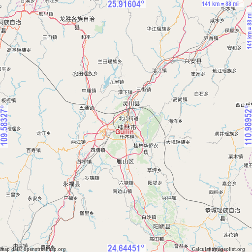
Guilin GPS coordinates[2]
25° 16' 54.984" North, 110° 17' 11.004" East
| Map corner | latitude | longitude |
|---|---|---|
| Upper-left | 25.91604°, | 109.58327° |
| Center: | 25.28194°, | 110.28639° |
| Lower-right: | 24.64451°, | 110.98952° |
| Map W x H: | 141.4×141.4 km | = 87.9×87.9mi |
| max Lat: | 53.31946° ⇑85.2% North |
| Guilin: | 25.28194° |
| min Lat: | ⇓14.8% South 18.22056° |
| min Long | Guilin | max Long |
| 75.07348° | 110.28639° | 134.28917° |
| W 29.9%⇐ | ⇒70.1% E |
Elevation
Elevation of Guilin is 160 m = 525 ft, and this is 324.8 m = 1066 ft below average elevation for this country.
| Max E: |
5622 m = 18445 ft | 50.5% |
| Avg. | 484.8 m = 1591 ft | |
| Guilin | 160 m = 525 ft | |
Min E: |
-3 m = -10 ft | 49.5% |
See also: Guilin elevation on elevation.city.
Geographical zone
Guilin is located in North temperate zone (between Tropic of Cancer and the Arctic Circle). Distance of this Northern Tropic circle is 205.2 km =127.5 mi to South.| Distance of | km | miles | from Guilin |
|---|---|---|---|
| North Pole | 7196 | 4471.4 | to North |
| Arctic Circle | 4590.1 | 2852.2 | to North |
| Tropic Cancer | 205.2 | 127.5 | to South |
| Equator | 2811.1 | 1746.7 | to South |


Nearby cities:
15 places around Guilin: (largest is in red/bold)
• Dazhai
60.3 km =37.5 mi,  346°
346°
• Gongcheng
73.1 km =45.4 mi,  133°
133°
• Guanyang
88.5 km =55 mi,  74°
74°
• Guyi
88.2 km =54.8 mi,  308°
308°
• Lanxi
89.9 km =55.9 mi,  103°
103°
• Licheng
86.8 km =53.9 mi,  173°
173°
• Lingchuan
14.6 km =9.1 mi,  14°
14°
• Longsheng
63.3 km =39.3 mi,  333°
333°
• Pingle
79.4 km =49.3 mi,  153°
153°
• Rong’an
91 km =56.5 mi,  266°
266°
• Xing’an
51.8 km =32.2 mi,  43°
43°
• Yangshuo
59.4 km =36.9 mi,  159°
159°
• Yongfu
43.5 km =27 mi,  224°
224°
• Yuankou
83.5 km =51.9 mi,  111°
111°
• Ziyuan
91.1 km =56.6 mi,  22°
22°
Sources, notices
• [Note1] Compared only with cities in China existing in our database
• [Src1] Map data: © OpenStreetMap contributors (CC-BY-SA)
• [Src2] Other city data from geonames.org with taken over terms of usage.
• [Src3] Geographical zone / Annual Mean Temperature by Robert A. Rohde @ Wikipedia
