Pingle geodata
Pingle (Guangxi) is a seat of a third-order administrative division; located in China in Asia/Shanghai (GMT+8) time zone. In our database, there are 1268 cities with bigger population. Compared to other cities in China, 87.9% of cities are located further ↑North; 68.5% of cities are located further →East and 59.4% of cities have higher elevation than Pingle. Note1


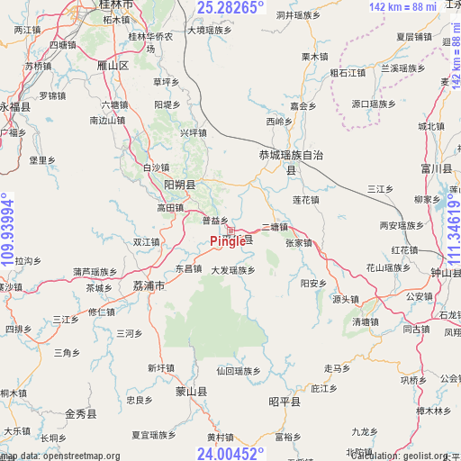
Pingle GPS coordinates[2]
24° 38' 42.792" North, 110° 38' 35.016" East
| Map corner | latitude | longitude |
|---|---|---|
| Upper-left | 25.28265°, | 109.93994° |
| Center: | 24.64522°, | 110.64306° |
| Lower-right: | 24.00452°, | 111.34619° |
| Map W x H: | 142.1×142.1 km | = 88.3×88.3mi |
| max Lat: | 53.31946° ⇑87.9% North |
| Pingle: | 24.64522° |
| min Lat: | ⇓12.1% South 18.22056° |
| min Long | Pingle | max Long |
| 75.07348° | 110.64306° | 134.28917° |
| W 31.5%⇐ | ⇒68.5% E |
Elevation
Elevation of Pingle is 102 m = 335 ft, and this is 382.8 m = 1256 ft below average elevation for this country.
| Max E: |
5622 m = 18445 ft | 59.4% |
| Avg. | 484.8 m = 1591 ft | |
| Pingle | 102 m = 335 ft | |
Min E: |
-3 m = -10 ft | 40.6% |
See also: China elevation on elevation.city.
Geographical zone
Pingle is located in North temperate zone (between Tropic of Cancer and the Arctic Circle). Distance of this Northern Tropic circle is 134.4 km =83.5 mi to South.| Distance of | km | miles | from Pingle |
|---|---|---|---|
| North Pole | 7266.8 | 4515.4 | to North |
| Arctic Circle | 4660.9 | 2896.1 | to North |
| Tropic Cancer | 134.4 | 83.5 | to South |
| Equator | 2740.3 | 1702.7 | to South |


Nearby cities:
15 places around Pingle: (largest is in red/bold)
• Babu
91.9 km =57.1 mi,  106°
106°
• Fuyang
65.6 km =40.8 mi,  71°
71°
• Gongcheng
27.3 km =17 mi,  39°
39°
• Guilin
79.4 km =49.3 mi,  333°
333°
• Jinxiu
73.4 km =45.6 mi,  219°
219°
• Lanxi
72.2 km =44.9 mi,  45°
45°
• Licheng
29.9 km =18.6 mi,  238°
238°
• Lingchuan
90.9 km =56.5 mi,  339°
339°
• Luzhai
93.5 km =58.1 mi,  259°
259°
• Mengshan
49.6 km =30.8 mi,  194°
194°
• Yangshuo
21.6 km =13.4 mi,  314°
314°
• Yongfu
77.7 km =48.3 mi,  300°
300°
• Yuankou
57.4 km =35.7 mi, 46°
• Zhaoping
54.6 km =33.9 mi,  164°
164°
• Zhongshan
67.6 km =42 mi,  100°
100°
Sources, notices
• [Note1] Compared only with cities in China existing in our database
• [Src1] Map data: © OpenStreetMap contributors (CC-BY-SA)
• [Src2] Other city data from geonames.org with taken over terms of usage.
• [Src3] Geographical zone / Annual Mean Temperature by Robert A. Rohde @ Wikipedia
