Zhaoping geodata
Zhaoping (Guangxi) is a seat of a third-order administrative division; located in China in Asia/Shanghai (GMT+8) time zone. In our database, there are 1268 cities with bigger population. Compared to other cities in China, 89.7% of cities are located further ↑North; 68% of cities are located further →East and 57.9% of cities have higher elevation than Zhaoping. Note1


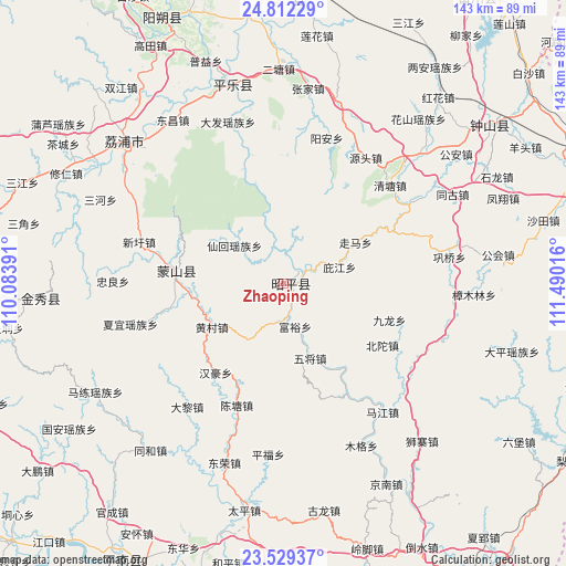
Zhaoping GPS coordinates[2]
24° 10' 20.784" North, 110° 47' 13.308" East
| Map corner | latitude | longitude |
|---|---|---|
| Upper-left | 24.81229°, | 110.08391° |
| Center: | 24.17244°, | 110.78703° |
| Lower-right: | 23.52937°, | 111.49016° |
| Map W x H: | 142.6×142.6 km | = 88.6×88.6mi |
| max Lat: | 53.31946° ⇑89.7% North |
| Zhaoping: | 24.17244° |
| min Lat: | ⇓10.3% South 18.22056° |
| min Long | Zhaoping | max Long |
| 75.07348° | 110.78703° | 134.28917° |
| W 32%⇐ | ⇒68% E |
Elevation
Elevation of Zhaoping is 112 m = 367 ft, and this is 372.8 m = 1223 ft below average elevation for this country.
| Max E: |
5622 m = 18445 ft | 57.9% |
| Avg. | 484.8 m = 1591 ft | |
| Zhaoping | 112 m = 367 ft | |
Min E: |
-3 m = -10 ft | 42.1% |
See also: China elevation on elevation.city.
Geographical zone
Zhaoping is located in North temperate zone (between Tropic of Cancer and the Arctic Circle). Distance of this Northern Tropic circle is 81.8 km =50.8 mi to South.| Distance of | km | miles | from Zhaoping |
|---|---|---|---|
| North Pole | 7319.3 | 4548 | to North |
| Arctic Circle | 4713.5 | 2928.8 | to North |
| Tropic Cancer | 81.8 | 50.8 | to South |
| Equator | 2687.7 | 1670.1 | to South |


Nearby cities:
15 places around Zhaoping: (largest is in red/bold)
• Babu
78.8 km =49 mi,  69°
69°
• Fuyang
87.7 km =54.5 mi,  32°
32°
• Gongcheng
73.5 km =45.7 mi,  2°
2°
• Jinji
105.1 km =65.3 mi,  177°
177°
• Jinxiu
61.7 km =38.3 mi,  266°
266°
• Licheng
54.8 km =34.1 mi,  312°
312°
• Longxu
95.5 km =59.3 mi,  151°
151°
• Mengshan
27.7 km =17.2 mi,  279°
279°
• Pingle
54.6 km =33.9 mi,  344°
344°
• Pingnan
80.9 km =50.3 mi,  209°
209°
• Tengzhou
87.9 km =54.6 mi,  173°
173°
• Wuzhou
93.7 km =58.2 mi,  144°
144°
• Yangshuo
74 km =46 mi, 336°
• Yuankou
96 km =59.7 mi,  16°
16°
• Zhongshan
65.7 km =40.8 mi,  52°
52°
Sources, notices
• [Note1] Compared only with cities in China existing in our database
• [Src1] Map data: © OpenStreetMap contributors (CC-BY-SA)
• [Src2] Other city data from geonames.org with taken over terms of usage.
• [Src3] Geographical zone / Annual Mean Temperature by Robert A. Rohde @ Wikipedia
