Yangce geodata
Yangce (Henan) is a seat of a fourth-order administrative division; located in China in Asia/Shanghai (GMT+8) time zone. In our database, there are 1268 cities with bigger population. Compared to other cities in China, 66% of cities are located further ↓South; 56% of cities are located further →East and 50.7% of cities have lower elevation than Yangce. Note1


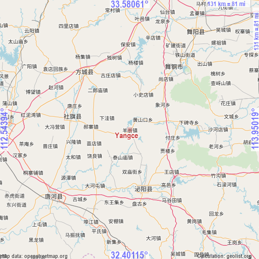
Yangce GPS coordinates[2]
32° 59' 34.26" North, 113° 14' 49.416" East
| Map corner | latitude | longitude |
|---|---|---|
| Upper-left | 33.58061°, | 112.54394° |
| Center: | 32.99285°, | 113.24706° |
| Lower-right: | 32.40115°, | 113.95019° |
| Map W x H: | 131.1×131.1 km | = 81.5×81.5mi |
| max Lat: | 53.31946° ⇑34% North |
| Yangce: | 32.99285° |
| min Lat: | ⇓66% South 18.22056° |
| min Long | Yangce | max Long |
| 75.07348° | 113.24706° | 134.28917° |
| W 44%⇐ | ⇒56% E |
Elevation
Elevation of Yangce is 171 m = 561 ft, and this is 313.8 m = 1030 ft below average elevation for this country.
| Max E: |
5622 m = 18445 ft | 49.3% |
| Avg. | 484.8 m = 1591 ft | |
| Yangce | 171 m = 561 ft | |
Min E: |
-3 m = -10 ft | 50.7% |
See also: China elevation on elevation.city.
Geographical zone
Yangce is located in North temperate zone (between Tropic of Cancer and the Arctic Circle). Distance of this Northern Tropic circle is 1062.5 km =660.2 mi to South.| Distance of | km | miles | from Yangce |
|---|---|---|---|
| North Pole | 6338.6 | 3938.6 | to North |
| Arctic Circle | 3732.7 | 2319.4 | to North |
| Tropic Cancer | 1062.5 | 660.2 | to South |
| Equator | 3668.5 | 2279.5 | to South |


Nearby cities:
15 places around Yangce: (largest is in red/bold)
• Chunshui
20.2 km =12.6 mi,  77°
77°
• Fuzhuang
22 km =13.7 mi,  99°
99°
• Guanzhuang
12.7 km =7.9 mi,  159°
159°
• Guoji
11.8 km =7.3 mi,  261°
261°
• Haozhai
19.9 km =12.4 mi,  275°
275°
• Huangshankou
8.4 km =5.2 mi,  50°
50°
• Jialou
21.9 km =13.6 mi,  119°
119°
• Shedian
29.4 km =18.3 mi,  285°
285°
• Shewan
28.8 km =17.9 mi,  181°
181°
• Shuangmiaojie
21 km =13 mi, 176°
• Taishanmiao
14.2 km =8.8 mi,  194°
194°
• Wangdian
29.8 km =18.5 mi,  134°
134°
• Xianghe
21 km =13 mi, 52°
• Xiaoshidian
19.3 km =12 mi,  20°
20°
• Yangjiaji
20.1 km =12.5 mi,  154°
154°
Sources, notices
• [Note1] Compared only with cities in China existing in our database
• [Src1] Map data: © OpenStreetMap contributors (CC-BY-SA)
• [Src2] Other city data from geonames.org with taken over terms of usage.
• [Src3] Geographical zone / Annual Mean Temperature by Robert A. Rohde @ Wikipedia
