Xianghe geodata
Xianghe (Henan) is a seat of a fourth-order administrative division; located in China in Asia/Shanghai (GMT+8) time zone. In our database, there are 1268 cities with bigger population. Compared to other cities in China, 66.6% of cities are located further ↓South; 54.8% of cities are located further →East and 50.1% of cities have lower elevation than Xianghe. Note1


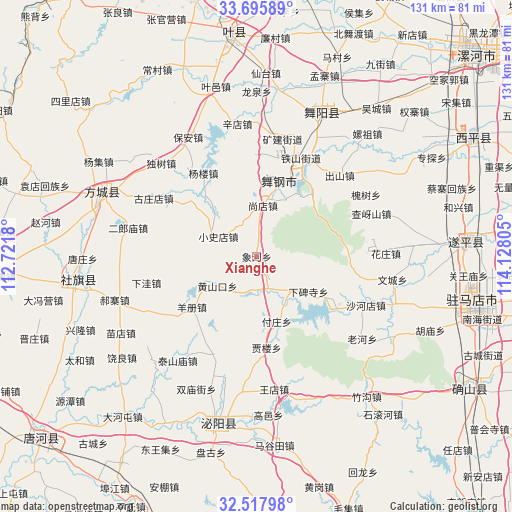
Xianghe GPS coordinates[2]
33° 6' 32.076" North, 113° 25' 29.712" East
| Map corner | latitude | longitude |
|---|---|---|
| Upper-left | 33.69589°, | 112.7218° |
| Center: | 33.10891°, | 113.42492° |
| Lower-right: | 32.51798°, | 114.12805° |
| Map W x H: | 131×131 km | = 81.4×81.4mi |
| max Lat: | 53.31946° ⇑33.4% North |
| Xianghe: | 33.10891° |
| min Lat: | ⇓66.6% South 18.22056° |
| min Long | Xianghe | max Long |
| 75.07348° | 113.42492° | 134.28917° |
| W 45.2%⇐ | ⇒54.8% E |
Elevation
Elevation of Xianghe is 166 m = 545 ft, and this is 318.8 m = 1046 ft below average elevation for this country.
| Max E: |
5622 m = 18445 ft | 49.9% |
| Avg. | 484.8 m = 1591 ft | |
| Xianghe | 166 m = 545 ft | |
Min E: |
-3 m = -10 ft | 50.1% |
See also: China elevation on elevation.city.
Geographical zone
Xianghe is located in North temperate zone (between Tropic of Cancer and the Arctic Circle). Distance of this Northern Tropic circle is 1075.4 km =668.2 mi to South.| Distance of | km | miles | from Xianghe |
|---|---|---|---|
| North Pole | 6325.7 | 3930.6 | to North |
| Arctic Circle | 3719.8 | 2311.4 | to North |
| Tropic Cancer | 1075.4 | 668.2 | to South |
| Equator | 3681.4 | 2287.5 | to South |


Nearby cities:
15 places around Xianghe: (largest is in red/bold)
• Banqiao
22.1 km =13.7 mi,  124°
124°
• Chunshui
9 km =5.6 mi,  160°
160°
• Fuzhuang
17.4 km =10.8 mi, 163°
• Huangshankou
12.6 km =7.8 mi,  233°
233°
• Jialou
23.9 km =14.9 mi,  174°
174°
• Shangdian
13.6 km =8.5 mi,  8°
8°
• Sipo
21 km =13 mi,  24°
24°
• Xiabeisi
16 km =9.9 mi, 124°
• Xiaoshidian
11 km =6.8 mi,  297°
297°
• Yakou
22.8 km =14.2 mi, 23°
• Yangce
21 km =13 mi, 232°
• Yangzhuang
18.5 km =11.5 mi, 16°
• Yinji
21.1 km =13.1 mi,  41°
41°
• Yuanling
19.6 km =12.2 mi, 9°
• Zhulan
25.3 km =15.7 mi, 22°
Sources, notices
• [Note1] Compared only with cities in China existing in our database
• [Src1] Map data: © OpenStreetMap contributors (CC-BY-SA)
• [Src2] Other city data from geonames.org with taken over terms of usage.
• [Src3] Geographical zone / Annual Mean Temperature by Robert A. Rohde @ Wikipedia
