Chunshui geodata
Chunshui (Henan) is a seat of a fourth-order administrative division; located in China in Asia/Shanghai (GMT+8) time zone. In our database, there are 1268 cities with bigger population. Compared to other cities in China, 66.3% of cities are located further ↓South; 54.6% of cities are located further →East and 53.4% of cities have higher elevation than Chunshui. Note1


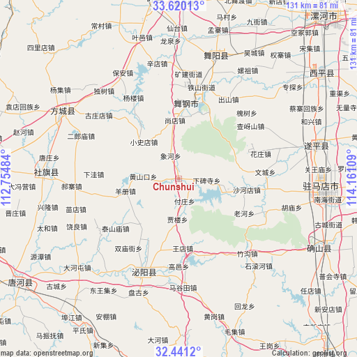
Chunshui GPS coordinates[2]
33° 1' 57.504" North, 113° 27' 28.656" East
| Map corner | latitude | longitude |
|---|---|---|
| Upper-left | 33.62013°, | 112.75484° |
| Center: | 33.03264°, | 113.45796° |
| Lower-right: | 32.4412°, | 114.16109° |
| Map W x H: | 131.1×131.1 km | = 81.5×81.5mi |
| max Lat: | 53.31946° ⇑33.7% North |
| Chunshui: | 33.03264° |
| min Lat: | ⇓66.3% South 18.22056° |
| min Long | Chunshui | max Long |
| 75.07348° | 113.45796° | 134.28917° |
| W 45.4%⇐ | ⇒54.6% E |
Elevation
Elevation of Chunshui is 141 m = 463 ft, and this is 343.8 m = 1128 ft below average elevation for this country.
| Max E: |
5622 m = 18445 ft | 53.4% |
| Avg. | 484.8 m = 1591 ft | |
| Chunshui | 141 m = 463 ft | |
Min E: |
-3 m = -10 ft | 46.6% |
See also: China elevation on elevation.city.
Geographical zone
Chunshui is located in North temperate zone (between Tropic of Cancer and the Arctic Circle). Distance of this Northern Tropic circle is 1067 km =663 mi to South.| Distance of | km | miles | from Chunshui |
|---|---|---|---|
| North Pole | 6334.2 | 3935.9 | to North |
| Arctic Circle | 3728.3 | 2316.7 | to North |
| Tropic Cancer | 1067 | 663 | to South |
| Equator | 3672.9 | 2282.2 | to South |


Nearby cities:
15 places around Chunshui: (largest is in red/bold)
• Banqiao
15.7 km =9.8 mi,  104°
104°
• Fuzhuang
8.5 km =5.3 mi,  166°
166°
• Guanzhuang
22.2 km =13.8 mi,  223°
223°
• Huangshankou
13.2 km =8.2 mi,  274°
274°
• Jialou
15.3 km =9.5 mi,  182°
182°
• Shahedian
25.2 km =15.7 mi, 99°
• Shangdian
21.9 km =13.6 mi,  357°
357°
• Wangdian
25.5 km =15.8 mi, 176°
• Xiabeisi
10.2 km =6.3 mi,  93°
93°
• Xianghe
9 km =5.6 mi,  340°
340°
• Xiaoshidian
18.7 km =11.6 mi,  316°
316°
• Yangce
20.2 km =12.6 mi,  257°
257°
• Yangjiaji
25.2 km =15.7 mi,  206°
206°
• Yangzhuang
26.3 km =16.3 mi,  4°
4°
• Yinji
26.6 km =16.5 mi,  24°
24°
Sources, notices
• [Note1] Compared only with cities in China existing in our database
• [Src1] Map data: © OpenStreetMap contributors (CC-BY-SA)
• [Src2] Other city data from geonames.org with taken over terms of usage.
• [Src3] Geographical zone / Annual Mean Temperature by Robert A. Rohde @ Wikipedia
