Xuhui geodata
Xuhui (Shanghai) is a seat of a third-order administrative division; located in China in Asia/Shanghai (GMT+8) time zone. In our database, there are 1268 cities with bigger population. Compared to other cities in China, 56.2% of cities are located further ↓South; 89.8% of cities are located further ←West and 88.7% of cities have higher elevation than Xuhui. Note1


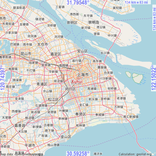
Xuhui GPS coordinates[2]
31° 11' 45.384" North, 121° 26' 49.524" East
| Map corner | latitude | longitude |
|---|---|---|
| Upper-left | 31.79548°, | 120.74397° |
| Center: | 31.19594°, | 121.44709° |
| Lower-right: | 30.59258°, | 122.15022° |
| Map W x H: | 133.7×133.7 km | = 83.1×83.1mi |
| max Lat: | 53.31946° ⇑43.8% North |
| Xuhui: | 31.19594° |
| min Lat: | ⇓56.2% South 18.22056° |
| min Long | Xuhui | max Long |
| 75.07348° | 121.44709° | 134.28917° |
| W 89.8%⇐ | ⇒10.2% E |
Elevation
Elevation of Xuhui is 11 m = 36 ft, and this is 473.8 m = 1554 ft below average elevation for this country.
| Max E: |
5622 m = 18445 ft | 88.7% |
| Avg. | 484.8 m = 1591 ft | |
| Xuhui | 11 m = 36 ft | |
Min E: |
-3 m = -10 ft | 11.3% |
See also: China elevation on elevation.city.
Geographical zone
Xuhui is located in North temperate zone (between Tropic of Cancer and the Arctic Circle). Distance of this Northern Tropic circle is 862.7 km =536.1 mi to South.| Distance of | km | miles | from Xuhui |
|---|---|---|---|
| North Pole | 6538.4 | 4062.8 | to North |
| Arctic Circle | 3932.5 | 2443.5 | to North |
| Tropic Cancer | 862.7 | 536.1 | to South |
| Equator | 3468.7 | 2155.3 | to South |


Nearby cities:
15 places around Xuhui: (largest is in red/bold)
• Changning
3.4 km =2.1 mi,  313°
313°
• Changqiao
6.1 km =3.8 mi,  191°
191°
• Changzheng
8.9 km =5.5 mi,  302°
302°
• Hongkou
7.2 km =4.5 mi,  33°
33°
• Huamu
9.4 km =5.8 mi,  79°
79°
• Jiangqiao
12.6 km =7.8 mi,  292°
292°
• Kangqiao
13.7 km =8.5 mi,  122°
122°
• Luwan
2.1 km =1.3 mi,  46°
46°
• Minhang
11.9 km =7.4 mi,  215°
215°
• Pudong
8.8 km =5.5 mi,  60°
60°
• Pujiang
12.3 km =7.6 mi,  157°
157°
• Shanghai
3.1 km =1.9 mi,  19°
19°
• Yangpu
10 km =6.2 mi,  42°
42°
• Zhabei
7.1 km =4.4 mi,  9°
9°
• Zhenxin
10.5 km =6.5 mi, 302°
Sources, notices
• [Note1] Compared only with cities in China existing in our database
• [Src1] Map data: © OpenStreetMap contributors (CC-BY-SA)
• [Src2] Other city data from geonames.org with taken over terms of usage.
• [Src3] Geographical zone / Annual Mean Temperature by Robert A. Rohde @ Wikipedia
