Hongkou geodata
Hongkou (Shanghai) is a seat of a third-order administrative division; located in China in Asia/Shanghai (GMT+8) time zone. In our database, there are 1268 cities with bigger population. Compared to other cities in China, 56.6% of cities are located further ↓South; 90% of cities are located further ←West and 100% of cities have higher elevation than Hongkou. Note1


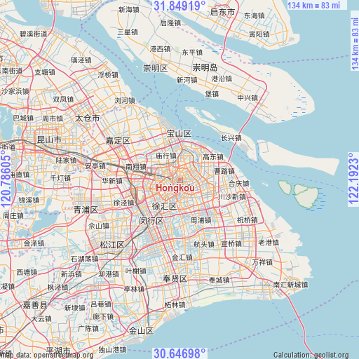
Hongkou GPS coordinates[2]
31° 15' 0" North, 121° 29' 21.012" East
| Map corner | latitude | longitude |
|---|---|---|
| Upper-left | 31.84919°, | 120.78605° |
| Center: | 31.25°, | 121.48917° |
| Lower-right: | 30.64698°, | 122.1923° |
| Map W x H: | 133.7×133.7 km | = 83.1×83.1mi |
| max Lat: | 53.31946° ⇑43.4% North |
| Hongkou: | 31.25° |
| min Lat: | ⇓56.6% South 18.22056° |
| min Long | Hongkou | max Long |
| 75.07348° | 121.48917° | 134.28917° |
| W 90%⇐ | ⇒10% E |
Elevation
Elevation of Hongkou is -3 m = -10 ft, and this is 487.8 m = 1600 ft below average elevation for this country.
| Max E: |
5622 m = 18445 ft | 100% |
| Avg. | 484.8 m = 1591 ft | |
| Hongkou | -3 m = -10 ft | |
Min E: |
-3 m = -10 ft | 0% |
See also: China elevation on elevation.city.
Geographical zone
Hongkou is located in North temperate zone (between Tropic of Cancer and the Arctic Circle). Distance of this Northern Tropic circle is 868.8 km =539.8 mi to South.| Distance of | km | miles | from Hongkou |
|---|---|---|---|
| North Pole | 6532.4 | 4059 | to North |
| Arctic Circle | 3926.5 | 2439.8 | to North |
| Tropic Cancer | 868.8 | 539.8 | to South |
| Equator | 3474.7 | 2159.1 | to South |


Nearby cities:
15 places around Hongkou: (largest is in red/bold)
• Baoshan
17.6 km =10.9 mi,  0°
0°
• Changning
7.4 km =4.6 mi,  240°
240°
• Changqiao
13.1 km =8.1 mi,  203°
203°
• Changzheng
11.6 km =7.2 mi,  264°
264°
• Huamu
6.8 km =4.2 mi,  129°
129°
• Jiangqiao
15.7 km =9.8 mi,  265°
265°
• Kangqiao
15.4 km =9.6 mi,  150°
150°
• Luwan
5.2 km =3.2 mi,  208°
208°
• Pudong
4 km =2.5 mi,  114°
114°
• Pujiang
17.4 km =10.8 mi,  177°
177°
• Shanghai
4.3 km =2.7 mi,  223°
223°
• Xuhui
7.2 km =4.5 mi, 213°
• Yangpu
3.1 km =1.9 mi,  64°
64°
• Zhabei
3 km =1.9 mi,  288°
288°
• Zhenxin
12.8 km =8 mi, 268°
Sources, notices
• [Note1] Compared only with cities in China existing in our database
• [Src1] Map data: © OpenStreetMap contributors (CC-BY-SA)
• [Src2] Other city data from geonames.org with taken over terms of usage.
• [Src3] Geographical zone / Annual Mean Temperature by Robert A. Rohde @ Wikipedia
