Luwan geodata
Luwan (Shanghai) is a seat of a third-order administrative division; located in China in Asia/Shanghai (GMT+8) time zone. In our database, there are 1268 cities with bigger population. Compared to other cities in China, 56.3% of cities are located further ↓South; 89.9% of cities are located further ←West and 87.7% of cities have higher elevation than Luwan. Note1


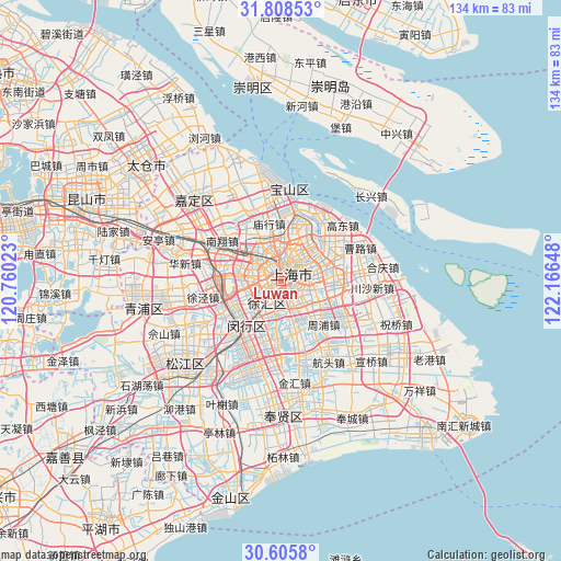
Luwan GPS coordinates[2]
31° 12' 32.688" North, 121° 27' 48.06" East
| Map corner | latitude | longitude |
|---|---|---|
| Upper-left | 31.80853°, | 120.76023° |
| Center: | 31.20908°, | 121.46335° |
| Lower-right: | 30.6058°, | 122.16648° |
| Map W x H: | 133.7×133.7 km | = 83.1×83.1mi |
| max Lat: | 53.31946° ⇑43.7% North |
| Luwan: | 31.20908° |
| min Lat: | ⇓56.3% South 18.22056° |
| min Long | Luwan | max Long |
| 75.07348° | 121.46335° | 134.28917° |
| W 89.9%⇐ | ⇒10.1% E |
Elevation
Elevation of Luwan is 12 m = 39 ft, and this is 472.8 m = 1551 ft below average elevation for this country.
| Max E: |
5622 m = 18445 ft | 87.7% |
| Avg. | 484.8 m = 1591 ft | |
| Luwan | 12 m = 39 ft | |
Min E: |
-3 m = -10 ft | 12.3% |
See also: China elevation on elevation.city.
Geographical zone
Luwan is located in North temperate zone (between Tropic of Cancer and the Arctic Circle). Distance of this Northern Tropic circle is 864.2 km =537 mi to South.| Distance of | km | miles | from Luwan |
|---|---|---|---|
| North Pole | 6536.9 | 4061.8 | to North |
| Arctic Circle | 3931 | 2442.6 | to North |
| Tropic Cancer | 864.2 | 537 | to South |
| Equator | 3470.1 | 2156.2 | to South |


Nearby cities:
15 places around Luwan: (largest is in red/bold)
• Changning
4.1 km =2.5 mi,  282°
282°
• Changqiao
8 km =5 mi,  200°
200°
• Changzheng
9.7 km =6 mi,  290°
290°
• Hongkou
5.2 km =3.2 mi,  28°
28°
• Huamu
7.7 km =4.8 mi,  88°
88°
• Jiangqiao
13.6 km =8.5 mi, 284°
• Kangqiao
13.4 km =8.3 mi,  131°
131°
• Minhang
14 km =8.7 mi,  217°
217°
• Pudong
6.8 km =4.2 mi,  64°
64°
• Pujiang
13.2 km =8.2 mi,  166°
166°
• Shanghai
1.5 km =0.9 mi,  341°
341°
• Xuhui
2.1 km =1.3 mi,  226°
226°
• Yangpu
7.9 km =4.9 mi,  42°
42°
• Zhabei
5.5 km =3.4 mi,  356°
356°
• Zhenxin
11.2 km =7 mi, 291°
Sources, notices
• [Note1] Compared only with cities in China existing in our database
• [Src1] Map data: © OpenStreetMap contributors (CC-BY-SA)
• [Src2] Other city data from geonames.org with taken over terms of usage.
• [Src3] Geographical zone / Annual Mean Temperature by Robert A. Rohde @ Wikipedia
