Yangpu geodata
Yangpu (Shanghai) is a seat of a third-order administrative division; located in China in Asia/Shanghai (GMT+8) time zone. In our database, there are 1268 cities with bigger population. Compared to other cities in China, 56.7% of cities are located further ↓South; 90.1% of cities are located further ←West and 91.2% of cities have higher elevation than Yangpu. Note1


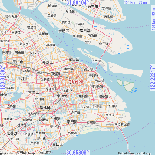
Yangpu GPS coordinates[2]
31° 15' 42.948" North, 121° 31' 8.544" East
| Map corner | latitude | longitude |
|---|---|---|
| Upper-left | 31.86104°, | 120.81592° |
| Center: | 31.26193°, | 121.51904° |
| Lower-right: | 30.65899°, | 122.22217° |
| Map W x H: | 133.7×133.7 km | = 83.1×83.1mi |
| max Lat: | 53.31946° ⇑43.3% North |
| Yangpu: | 31.26193° |
| min Lat: | ⇓56.7% South 18.22056° |
| min Long | Yangpu | max Long |
| 75.07348° | 121.51904° | 134.28917° |
| W 90.1%⇐ | ⇒9.9% E |
Elevation
Elevation of Yangpu is 9 m = 30 ft, and this is 475.8 m = 1561 ft below average elevation for this country.
| Max E: |
5622 m = 18445 ft | 91.2% |
| Avg. | 484.8 m = 1591 ft | |
| Yangpu | 9 m = 30 ft | |
Min E: |
-3 m = -10 ft | 8.8% |
See also: China elevation on elevation.city.
Geographical zone
Yangpu is located in North temperate zone (between Tropic of Cancer and the Arctic Circle). Distance of this Northern Tropic circle is 870.1 km =540.7 mi to South.| Distance of | km | miles | from Yangpu |
|---|---|---|---|
| North Pole | 6531.1 | 4058.2 | to North |
| Arctic Circle | 3925.2 | 2439 | to North |
| Tropic Cancer | 870.1 | 540.7 | to South |
| Equator | 3476 | 2159.9 | to South |


Nearby cities:
15 places around Yangpu: (largest is in red/bold)
• Baoshan
16.5 km =10.3 mi,  350°
350°
• Changning
10.6 km =6.6 mi,  242°
242°
• Changqiao
15.6 km =9.7 mi,  211°
211°
• Changzheng
14.6 km =9.1 mi,  259°
259°
• Hongkou
3.1 km =1.9 mi, 244°
• Huamu
6.1 km =3.8 mi,  157°
157°
• Jiangqiao
18.6 km =11.6 mi, 262°
• Kangqiao
15.5 km =9.6 mi, 162°
• Luwan
7.9 km =4.9 mi,  222°
222°
• Pudong
3.1 km =1.9 mi, 164°
• Pujiang
18.8 km =11.7 mi,  186°
186°
• Shanghai
7.3 km =4.5 mi,  232°
232°
• Xuhui
10 km =6.2 mi, 222°
• Zhabei
5.7 km =3.5 mi,  266°
266°
• Zhenxin
15.8 km =9.8 mi, 263°
Sources, notices
• [Note1] Compared only with cities in China existing in our database
• [Src1] Map data: © OpenStreetMap contributors (CC-BY-SA)
• [Src2] Other city data from geonames.org with taken over terms of usage.
• [Src3] Geographical zone / Annual Mean Temperature by Robert A. Rohde @ Wikipedia
