Xuchang geodata
Xuchang (Henan) is a seat of a second-order administrative division; located in China in Asia/Shanghai (GMT+8) time zone. With population of 1,265,536 people, there are 53 cities with bigger population in this country. Compared to other cities in China, 70.2% of cities are located further ↓South; 52.2% of cities are located further →East and 65.3% of cities have higher elevation than Xuchang. Note1


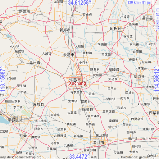
Xuchang GPS coordinates[2]
34° 1' 54.804" North, 113° 51' 46.764" East
| Map corner | latitude | longitude |
|---|---|---|
| Upper-left | 34.61258°, | 113.15987° |
| Center: | 34.03189°, | 113.86299° |
| Lower-right: | 33.4472°, | 114.56612° |
| Map W x H: | 129.6×129.6 km | = 80.5×80.5mi |
| max Lat: | 53.31946° ⇑29.8% North |
| Xuchang: | 34.03189° |
| min Lat: | ⇓70.2% South 18.22056° |
| min Long | Xuchang | max Long |
| 75.07348° | 113.86299° | 134.28917° |
| W 47.8%⇐ | ⇒52.2% E |
Elevation
Elevation of Xuchang is 71 m = 233 ft, and this is 413.8 m = 1358 ft below average elevation for this country.
| Max E: |
5622 m = 18445 ft | 65.3% |
| Avg. | 484.8 m = 1591 ft | |
| Xuchang | 71 m = 233 ft | |
Min E: |
-3 m = -10 ft | 34.7% |
See also: Xuchang elevation on elevation.city.
Geographical zone
Xuchang is located in North temperate zone (between Tropic of Cancer and the Arctic Circle). Distance of this Northern Tropic circle is 1178.1 km =732 mi to South.| Distance of | km | miles | from Xuchang |
|---|---|---|---|
| North Pole | 6223.1 | 3866.9 | to North |
| Arctic Circle | 3617.2 | 2247.6 | to North |
| Tropic Cancer | 1178.1 | 732 | to South |
| Equator | 3784 | 2351.3 | to South |


Nearby cities:
15 places around Xuchang: (largest is in red/bold)
• Daguo
27.5 km =17.1 mi,  193°
193°
• Duqu
24.3 km =15.1 mi,  179°
179°
• Fanhu
26.7 km =16.6 mi,  218°
218°
• Guxiang
18.4 km =11.4 mi,  163°
163°
• Jiangguanchi
3.5 km =2.2 mi,  170°
170°
• Jiangliji
10.5 km =6.5 mi, 194°
• Jianshe
22.4 km =13.9 mi,  337°
337°
• Juling
20.9 km =13 mi,  154°
154°
• Shenjian
16.3 km =10.1 mi,  264°
264°
• Shiqiao
12.3 km =7.6 mi, 164°
• Shuangmiao
25.2 km =15.7 mi,  236°
236°
• Wangmeng
14.3 km =8.9 mi,  143°
143°
• Yingqiao
26.7 km =16.6 mi,  253°
253°
• Yingyang
24.8 km =15.4 mi, 248°
• Zhangpan
12.5 km =7.8 mi,  110°
110°
Sources, notices
• [Note1] Compared only with cities in China existing in our database
• [Src1] Map data: © OpenStreetMap contributors (CC-BY-SA)
• [Src2] Other city data from geonames.org with taken over terms of usage.
• [Src3] Geographical zone / Annual Mean Temperature by Robert A. Rohde @ Wikipedia
