Jiangguanchi geodata
Jiangguanchi (Henan) is a seat of a fourth-order administrative division; located in China in Asia/Shanghai (GMT+8) time zone. In our database, there are 1268 cities with bigger population. Compared to other cities in China, 70.1% of cities are located further ↓South; 52.2% of cities are located further →East and 66.1% of cities have higher elevation than Jiangguanchi. Note1


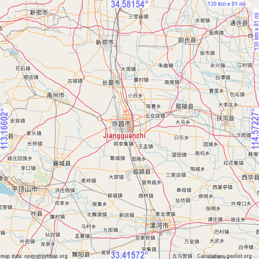
Jiangguanchi GPS coordinates[2]
34° 0' 2.268" North, 113° 52' 8.904" East
| Map corner | latitude | longitude |
|---|---|---|
| Upper-left | 34.58154°, | 113.16602° |
| Center: | 34.00063°, | 113.86914° |
| Lower-right: | 33.41572°, | 114.57227° |
| Map W x H: | 129.6×129.6 km | = 80.5×80.5mi |
| max Lat: | 53.31946° ⇑29.9% North |
| Jiangguanchi: | 34.00063° |
| min Lat: | ⇓70.1% South 18.22056° |
| min Long | Jiangguanchi | max Long |
| 75.07348° | 113.86914° | 134.28917° |
| W 47.8%⇐ | ⇒52.2% E |
Elevation
Elevation of Jiangguanchi is 68 m = 223 ft, and this is 416.8 m = 1367 ft below average elevation for this country.
| Max E: |
5622 m = 18445 ft | 66.1% |
| Avg. | 484.8 m = 1591 ft | |
| Jiangguanchi | 68 m = 223 ft | |
Min E: |
-3 m = -10 ft | 33.9% |
See also: China elevation on elevation.city.
Geographical zone
Jiangguanchi is located in North temperate zone (between Tropic of Cancer and the Arctic Circle). Distance of this Northern Tropic circle is 1174.6 km =729.9 mi to South.| Distance of | km | miles | from Jiangguanchi |
|---|---|---|---|
| North Pole | 6226.5 | 3869 | to North |
| Arctic Circle | 3620.7 | 2249.8 | to North |
| Tropic Cancer | 1174.6 | 729.9 | to South |
| Equator | 3780.5 | 2349.1 | to South |


Nearby cities:
15 places around Jiangguanchi: (largest is in red/bold)
• Daguo
24.3 km =15.1 mi,  196°
196°
• Duqu
20.9 km =13 mi,  181°
181°
• Fanhu
24.5 km =15.2 mi,  225°
225°
• Guxiang
14.9 km =9.3 mi,  161°
161°
• Jiangliji
7.4 km =4.6 mi,  205°
205°
• Jianshe
25.8 km =16 mi,  339°
339°
• Juling
17.5 km =10.9 mi,  151°
151°
• Shenjian
16.9 km =10.5 mi,  276°
276°
• Shiqiao
8.8 km =5.5 mi, 162°
• Shuangmiao
24 km =14.9 mi,  244°
244°
• Taichen
26.2 km =16.3 mi,  169°
169°
• Wangmeng
11.3 km =7 mi,  135°
135°
• Xuchang
3.5 km =2.2 mi,  350°
350°
• Yingyang
24.4 km =15.2 mi,  256°
256°
• Zhangpan
11.2 km =7 mi,  94°
94°
Sources, notices
• [Note1] Compared only with cities in China existing in our database
• [Src1] Map data: © OpenStreetMap contributors (CC-BY-SA)
• [Src2] Other city data from geonames.org with taken over terms of usage.
• [Src3] Geographical zone / Annual Mean Temperature by Robert A. Rohde @ Wikipedia
