Zijin geodata
Zijin (Henan) is a seat of a third-order administrative division; located in China in Asia/Shanghai (GMT+8) time zone. In our database, there are 1268 cities with bigger population. Compared to other cities in China, 67.4% of cities are located further ↓South; 65.1% of cities are located further →East and 55.9% of cities have lower elevation than Zijin. Note1


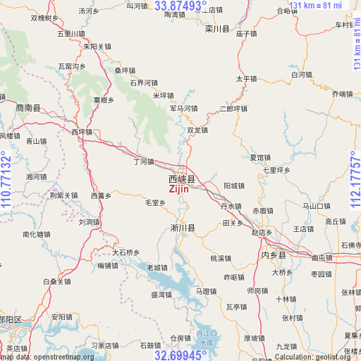
Zijin GPS coordinates[2]
33° 17' 21.012" North, 111° 28' 27.984" East
| Map corner | latitude | longitude |
|---|---|---|
| Upper-left | 33.87493°, | 110.77132° |
| Center: | 33.28917°, | 111.47444° |
| Lower-right: | 32.69945°, | 112.17757° |
| Map W x H: | 130.7×130.7 km | = 81.2×81.2mi |
| max Lat: | 53.31946° ⇑32.6% North |
| Zijin: | 33.28917° |
| min Lat: | ⇓67.4% South 18.22056° |
| min Long | Zijin | max Long |
| 75.07348° | 111.47444° | 134.28917° |
| W 34.9%⇐ | ⇒65.1% E |
Elevation
Elevation of Zijin is 215 m = 705 ft, and this is 269.8 m = 885 ft below average elevation for this country.
| Max E: |
5622 m = 18445 ft | 44.1% |
| Avg. | 484.8 m = 1591 ft | |
| Zijin | 215 m = 705 ft | |
Min E: |
-3 m = -10 ft | 55.9% |
See also: China elevation on elevation.city.
Geographical zone
Zijin is located in North temperate zone (between Tropic of Cancer and the Arctic Circle). Distance of this Northern Tropic circle is 1095.5 km =680.7 mi to South.| Distance of | km | miles | from Zijin |
|---|---|---|---|
| North Pole | 6305.7 | 3918.2 | to North |
| Arctic Circle | 3699.8 | 2298.9 | to North |
| Tropic Cancer | 1095.5 | 680.7 | to South |
| Equator | 3701.4 | 2299.9 | to South |


Nearby cities:
15 places around Zijin: (largest is in red/bold)
• Bailang
45.5 km =28.3 mi,  262°
262°
• Baisangguan
57.8 km =35.9 mi,  231°
231°
• Gaoqiu
57.8 km =35.9 mi,  104°
104°
• Haoping
63.7 km =39.6 mi,  198°
198°
• Liudong
36.6 km =22.7 mi,  245°
245°
• Luanchuan Chengguanzhen
56.2 km =34.9 mi,  13°
13°
• Luyi
57.3 km =35.6 mi,  111°
111°
• Mashankou
50 km =31.1 mi, 100°
• Meipu
40.5 km =25.2 mi,  220°
220°
• Nanhuatang
56 km =34.8 mi, 249°
• Neixiang Chengguanzhen
43.7 km =27.2 mi,  128°
128°
• Qutun
58.3 km =36.2 mi,  118°
118°
• Shigu
60.6 km =37.7 mi,  190°
190°
• Tanshan
43.8 km =27.2 mi, 228°
• Wanggang
60.7 km =37.7 mi, 110°
Sources, notices
• [Note1] Compared only with cities in China existing in our database
• [Src1] Map data: © OpenStreetMap contributors (CC-BY-SA)
• [Src2] Other city data from geonames.org with taken over terms of usage.
• [Src3] Geographical zone / Annual Mean Temperature by Robert A. Rohde @ Wikipedia
