Meipu geodata
Meipu (Hubei) is a seat of a fourth-order administrative division; located in China in Asia/Shanghai (GMT+8) time zone. In our database, there are 1268 cities with bigger population. Compared to other cities in China, 66.1% of cities are located further ↓South; 66.3% of cities are located further →East and 54.5% of cities have lower elevation than Meipu. Note1


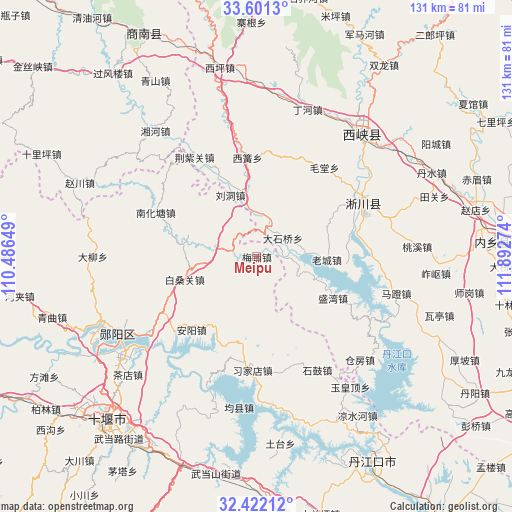
Meipu GPS coordinates[2]
33° 0' 49.248" North, 111° 11' 22.596" East
| Map corner | latitude | longitude |
|---|---|---|
| Upper-left | 33.6013°, | 110.48649° |
| Center: | 33.01368°, | 111.18961° |
| Lower-right: | 32.42212°, | 111.89274° |
| Map W x H: | 131.1×131.1 km | = 81.5×81.5mi |
| max Lat: | 53.31946° ⇑33.9% North |
| Meipu: | 33.01368° |
| min Lat: | ⇓66.1% South 18.22056° |
| min Long | Meipu | max Long |
| 75.07348° | 111.18961° | 134.28917° |
| W 33.7%⇐ | ⇒66.3% E |
Elevation
Elevation of Meipu is 201 m = 659 ft, and this is 283.8 m = 931 ft below average elevation for this country.
| Max E: |
5622 m = 18445 ft | 45.5% |
| Avg. | 484.8 m = 1591 ft | |
| Meipu | 201 m = 659 ft | |
Min E: |
-3 m = -10 ft | 54.5% |
See also: China elevation on elevation.city.
Geographical zone
Meipu is located in North temperate zone (between Tropic of Cancer and the Arctic Circle). Distance of this Northern Tropic circle is 1064.9 km =661.7 mi to South.| Distance of | km | miles | from Meipu |
|---|---|---|---|
| North Pole | 6336.3 | 3937.2 | to North |
| Arctic Circle | 3730.4 | 2318 | to North |
| Tropic Cancer | 1064.9 | 661.7 | to South |
| Equator | 3670.8 | 2280.9 | to South |


Nearby cities:
15 places around Meipu: (largest is in red/bold)
• Anyang
25 km =15.5 mi,  221°
221°
• Bailang
30.9 km =19.2 mi,  322°
322°
• Baisangguan
19.4 km =12.1 mi,  252°
252°
• Haoping
30.6 km =19 mi,  167°
167°
• Junxian
38.8 km =24.1 mi,  186°
186°
• Liudong
17.2 km =10.7 mi,  336°
336°
• Nanhuatang
28.4 km =17.6 mi,  293°
293°
• Qingshan
40.6 km =25.2 mi, 219°
• Shigu
32.9 km =20.4 mi,  151°
151°
• Tanshan
6.5 km =4 mi,  284°
284°
• Xijiadian
29.1 km =18.1 mi,  182°
182°
• Yangxipu
35.3 km =21.9 mi,  235°
235°
• Yuhuangding
41.1 km =25.5 mi,  144°
144°
• Yunxian Chengguanzhen
40.9 km =25.4 mi, 240°
• Zijin
40.5 km =25.2 mi,  40°
40°
Sources, notices
• [Note1] Compared only with cities in China existing in our database
• [Src1] Map data: © OpenStreetMap contributors (CC-BY-SA)
• [Src2] Other city data from geonames.org with taken over terms of usage.
• [Src3] Geographical zone / Annual Mean Temperature by Robert A. Rohde @ Wikipedia
