Liudong geodata
Liudong (Hubei) is a seat of a fourth-order administrative division; located in China in Asia/Shanghai (GMT+8) time zone. In our database, there are 1268 cities with bigger population. Compared to other cities in China, 66.9% of cities are located further ↓South; 66.6% of cities are located further →East and 54.1% of cities have lower elevation than Liudong. Note1


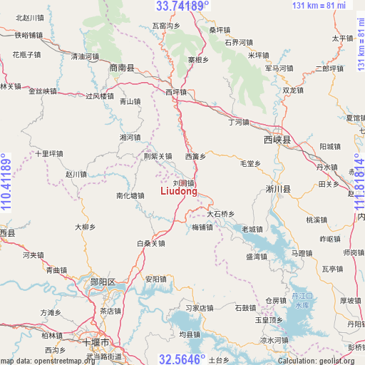
Liudong GPS coordinates[2]
33° 9' 18.792" North, 111° 6' 54.036" East
| Map corner | latitude | longitude |
|---|---|---|
| Upper-left | 33.74189°, | 110.41189° |
| Center: | 33.15522°, | 111.11501° |
| Lower-right: | 32.5646°, | 111.81814° |
| Map W x H: | 130.9×130.9 km | = 81.3×81.3mi |
| max Lat: | 53.31946° ⇑33.1% North |
| Liudong: | 33.15522° |
| min Lat: | ⇓66.9% South 18.22056° |
| min Long | Liudong | max Long |
| 75.07348° | 111.11501° | 134.28917° |
| W 33.4%⇐ | ⇒66.6% E |
Elevation
Elevation of Liudong is 198 m = 650 ft, and this is 286.8 m = 941 ft below average elevation for this country.
| Max E: |
5622 m = 18445 ft | 45.9% |
| Avg. | 484.8 m = 1591 ft | |
| Liudong | 198 m = 650 ft | |
Min E: |
-3 m = -10 ft | 54.1% |
See also: China elevation on elevation.city.
Geographical zone
Liudong is located in North temperate zone (between Tropic of Cancer and the Arctic Circle). Distance of this Northern Tropic circle is 1080.6 km =671.5 mi to South.| Distance of | km | miles | from Liudong |
|---|---|---|---|
| North Pole | 6320.5 | 3927.4 | to North |
| Arctic Circle | 3714.7 | 2308.2 | to North |
| Tropic Cancer | 1080.6 | 671.5 | to South |
| Equator | 3686.5 | 2290.7 | to South |


Nearby cities:
15 places around Liudong: (largest is in red/bold)
• Anyang
35.8 km =22.2 mi,  195°
195°
• Bailang
14.7 km =9.1 mi,  307°
307°
• Baisangguan
24.3 km =15.1 mi,  208°
208°
• Daliu
38.5 km =23.9 mi,  246°
246°
• Haoping
47.5 km =29.5 mi,  163°
163°
• Liubei
51.2 km =31.8 mi,  220°
220°
• Meipu
17.2 km =10.7 mi, 156°
• Nanhuatang
19.6 km =12.2 mi,  257°
257°
• Qingshan
50.8 km =31.6 mi, 201°
• Shigu
50.1 km =31.1 mi,  153°
153°
• Tanshan
14.1 km =8.8 mi,  177°
177°
• Xijiadian
45.2 km =28.1 mi,  172°
172°
• Yangxipu
41.9 km =26 mi, 212°
• Yunxian Chengguanzhen
46 km =28.6 mi, 218°
• Zijin
36.6 km =22.7 mi,  65°
65°
Sources, notices
• [Note1] Compared only with cities in China existing in our database
• [Src1] Map data: © OpenStreetMap contributors (CC-BY-SA)
• [Src2] Other city data from geonames.org with taken over terms of usage.
• [Src3] Geographical zone / Annual Mean Temperature by Robert A. Rohde @ Wikipedia
