Xitou geodata
Xitou (Guangdong) is a seat of a fourth-order administrative division; located in China in Asia/Shanghai (GMT+8) time zone. In our database, there are 1268 cities with bigger population. Compared to other cities in China, 97.8% of cities are located further ↑North; 63.8% of cities are located further →East and 92.7% of cities have higher elevation than Xitou. Note1


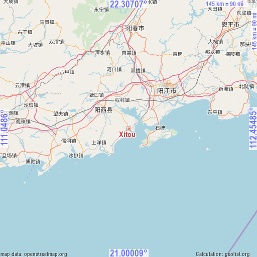
Xitou GPS coordinates[2]
21° 39' 18.216" North, 111° 45' 6.192" East
| Map corner | latitude | longitude |
|---|---|---|
| Upper-left | 22.30707°, | 111.0486° |
| Center: | 21.65506°, | 111.75172° |
| Lower-right: | 21.00009°, | 112.45485° |
| Map W x H: | 145.3×145.3 km | = 90.3×90.3mi |
| max Lat: | 53.31946° ⇑97.8% North |
| Xitou: | 21.65506° |
| min Lat: | ⇓2.2% South 18.22056° |
| min Long | Xitou | max Long |
| 75.07348° | 111.75172° | 134.28917° |
| W 36.2%⇐ | ⇒63.8% E |
Elevation
Elevation of Xitou is 8 m = 26 ft, and this is 476.8 m = 1564 ft below average elevation for this country.
| Max E: |
5622 m = 18445 ft | 92.7% |
| Avg. | 484.8 m = 1591 ft | |
| Xitou | 8 m = 26 ft | |
Min E: |
-3 m = -10 ft | 7.3% |
See also: China elevation on elevation.city.
Geographical zone
Xitou is located in North Torrid zone (between Equator and Tropic of Cancer). Distance of this Northern Tropic circle is 198.1 km =123.1 mi to North.| Distance of | km | miles | from Xitou |
|---|---|---|---|
| North Pole | 7599.2 | 4721.9 | to North |
| Arctic Circle | 4993.4 | 3102.8 | to North |
| Tropic Cancer | 198.1 | 123.1 | to North |
| Equator | 2407.8 | 1496.1 | to South |


Nearby cities:
15 places around Xitou: (largest is in red/bold)
• Baisha
27.3 km =17 mi,  27°
27°
• Buchang
22.3 km =13.9 mi,  52°
52°
• Chengcun
17.2 km =10.7 mi,  343°
343°
• Chengxi
27 km =16.8 mi, 45°
• Ganglie
30.7 km =19.1 mi, 45°
• Pinggang
17.1 km =10.6 mi, 49°
• Shaba Zhen
31.4 km =19.5 mi,  244°
244°
• Shangyang
18.2 km =11.3 mi,  246°
246°
• Shapa
31.4 km =19.5 mi, 244°
• Shuangjie
32.2 km =20 mi,  5°
5°
• Tangkou
27 km =16.8 mi,  316°
316°
• Xinxu
31.9 km =19.8 mi,  279°
279°
• Yangjiang
31.2 km =19.4 mi,  44°
44°
• Zhigong
17.3 km =10.7 mi,  304°
304°
• Zhize
18.1 km =11.2 mi,  308°
308°
Sources, notices
• [Note1] Compared only with cities in China existing in our database
• [Src1] Map data: © OpenStreetMap contributors (CC-BY-SA)
• [Src2] Other city data from geonames.org with taken over terms of usage.
• [Src3] Geographical zone / Annual Mean Temperature by Robert A. Rohde @ Wikipedia
