Shapa geodata
Shapa (Guangdong) is a seat of a fourth-order administrative division; located in China in Asia/Shanghai (GMT+8) time zone. In our database, there are 1268 cities with bigger population. Compared to other cities in China, 98% of cities are located further ↑North; 65.1% of cities are located further →East and 87.7% of cities have higher elevation than Shapa. Note1


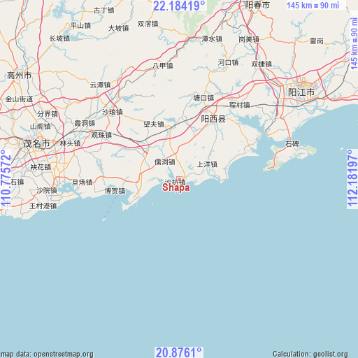
Shapa GPS coordinates[2]
21° 31' 53.832" North, 111° 28' 43.824" East
| Map corner | latitude | longitude |
|---|---|---|
| Upper-left | 22.18419°, | 110.77572° |
| Center: | 21.53162°, | 111.47884° |
| Lower-right: | 20.8761°, | 112.18197° |
| Map W x H: | 145.4×145.4 km | = 90.3×90.3mi |
| max Lat: | 53.31946° ⇑98% North |
| Shapa: | 21.53162° |
| min Lat: | ⇓2% South 18.22056° |
| min Long | Shapa | max Long |
| 75.07348° | 111.47884° | 134.28917° |
| W 34.9%⇐ | ⇒65.1% E |
Elevation
Elevation of Shapa is 12 m = 39 ft, and this is 472.8 m = 1551 ft below average elevation for this country.
| Max E: |
5622 m = 18445 ft | 87.7% |
| Avg. | 484.8 m = 1591 ft | |
| Shapa | 12 m = 39 ft | |
Min E: |
-3 m = -10 ft | 12.3% |
See also: China elevation on elevation.city.
Geographical zone
Shapa is located in North Torrid zone (between Equator and Tropic of Cancer). Distance of this Northern Tropic circle is 211.8 km =131.6 mi to North.| Distance of | km | miles | from Shapa |
|---|---|---|---|
| North Pole | 7613 | 4730.5 | to North |
| Arctic Circle | 5007.1 | 3111.3 | to North |
| Tropic Cancer | 211.8 | 131.6 | to North |
| Equator | 2394.1 | 1487.6 | to South |


Nearby cities:
15 places around Shapa: (largest is in red/bold)
• Bohe
27.3 km =17 mi,  260°
260°
• Diancheng
18.6 km =11.6 mi, 264°
• Lingmen
10.4 km =6.5 mi,  294°
294°
• Magang
32.2 km =20 mi,  272°
272°
• Mata
16 km =9.9 mi,  301°
301°
• Rudong
8.9 km =5.5 mi,  328°
328°
• Shaba Zhen
0 km =0 mi,  0°
0°
• Shangyang
13.2 km =8.2 mi,  60°
60°
• Shuzi
26.5 km =16.5 mi, 273°
• Tangkou
34.8 km =21.6 mi,  16°
16°
• Wangfu
25 km =15.5 mi, 333°
• Xinxu
19.5 km =12.1 mi,  350°
350°
• Xitou
31.4 km =19.5 mi, 64°
• Zhigong
27.3 km =17 mi,  30°
30°
• Zhize
28.6 km =17.8 mi, 29°
Sources, notices
• [Note1] Compared only with cities in China existing in our database
• [Src1] Map data: © OpenStreetMap contributors (CC-BY-SA)
• [Src2] Other city data from geonames.org with taken over terms of usage.
• [Src3] Geographical zone / Annual Mean Temperature by Robert A. Rohde @ Wikipedia
