Baisha geodata
Baisha (Guangdong) is a seat of a fourth-order administrative division; located in China in Asia/Shanghai (GMT+8) time zone. In our database, there are 1268 cities with bigger population. Compared to other cities in China, 97.4% of cities are located further ↑North; 63.2% of cities are located further →East and 89.9% of cities have higher elevation than Baisha. Note1


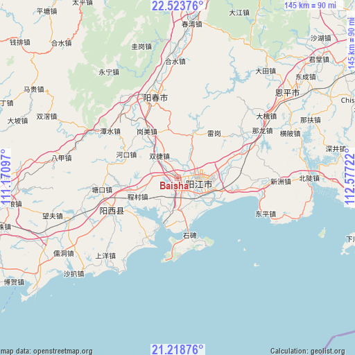
Baisha GPS coordinates[2]
21° 52' 21.9" North, 111° 52' 26.724" East
| Map corner | latitude | longitude |
|---|---|---|
| Upper-left | 22.52376°, | 111.17097° |
| Center: | 21.87275°, | 111.87409° |
| Lower-right: | 21.21876°, | 112.57722° |
| Map W x H: | 145.1×145.1 km | = 90.2×90.2mi |
| max Lat: | 53.31946° ⇑97.4% North |
| Baisha: | 21.87275° |
| min Lat: | ⇓2.6% South 18.22056° |
| min Long | Baisha | max Long |
| 75.07348° | 111.87409° | 134.28917° |
| W 36.8%⇐ | ⇒63.2% E |
Elevation
Elevation of Baisha is 10 m = 33 ft, and this is 474.8 m = 1558 ft below average elevation for this country.
| Max E: |
5622 m = 18445 ft | 89.9% |
| Avg. | 484.8 m = 1591 ft | |
| Baisha | 10 m = 33 ft | |
Min E: |
-3 m = -10 ft | 10.1% |
See also: China elevation on elevation.city.
Geographical zone
Baisha is located in North Torrid zone (between Equator and Tropic of Cancer). Distance of this Northern Tropic circle is 173.9 km =108.1 mi to North.| Distance of | km | miles | from Baisha |
|---|---|---|---|
| North Pole | 7575 | 4706.9 | to North |
| Arctic Circle | 4969.2 | 3087.7 | to North |
| Tropic Cancer | 173.9 | 108.1 | to North |
| Equator | 2432 | 1511.2 | to South |


Nearby cities:
15 places around Baisha: (largest is in red/bold)
• Beiguan
21 km =13 mi,  71°
71°
• Buchang
11.6 km =7.2 mi,  154°
154°
• Chengcun
19 km =11.8 mi,  246°
246°
• Chengxi
8.4 km =5.2 mi,  128°
128°
• Daba
24 km =14.9 mi,  21°
21°
• Dongcheng
14.1 km =8.8 mi,  85°
85°
• Ganglie
9.5 km =5.9 mi,  105°
105°
• Gangmei
22.9 km =14.2 mi,  326°
326°
• Hekou
22.3 km =13.9 mi,  297°
297°
• Pinggang
13.1 km =8.1 mi,  178°
178°
• Shuangjie
12.4 km =7.7 mi,  309°
309°
• Tangping
18.8 km =11.7 mi, 19°
• Xitou
27.3 km =17 mi,  207°
207°
• Yangjiang
9.3 km =5.8 mi,  101°
101°
• Yashao
18.9 km =11.7 mi, 107°
Sources, notices
• [Note1] Compared only with cities in China existing in our database
• [Src1] Map data: © OpenStreetMap contributors (CC-BY-SA)
• [Src2] Other city data from geonames.org with taken over terms of usage.
• [Src3] Geographical zone / Annual Mean Temperature by Robert A. Rohde @ Wikipedia
