Xishenba geodata
Xishenba (Shaanxi) is a seat of a fourth-order administrative division; located in China in Asia/Shanghai (GMT+8) time zone. In our database, there are 1268 cities with bigger population. Compared to other cities in China, 65.2% of cities are located further ↓South; 83.9% of cities are located further →East and 80.8% of cities have lower elevation than Xishenba. Note1


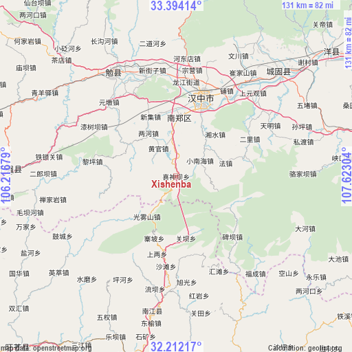
Xishenba GPS coordinates[2]
32° 48' 18.432" North, 106° 55' 11.676" East
| Map corner | latitude | longitude |
|---|---|---|
| Upper-left | 33.39414°, | 106.21679° |
| Center: | 32.80512°, | 106.91991° |
| Lower-right: | 32.21217°, | 107.62304° |
| Map W x H: | 131.4×131.4 km | = 81.6×81.6mi |
| max Lat: | 53.31946° ⇑34.8% North |
| Xishenba: | 32.80512° |
| min Lat: | ⇓65.2% South 18.22056° |
| min Long | Xishenba | max Long |
| 75.07348° | 106.91991° | 134.28917° |
| W 16.1%⇐ | ⇒83.9% E |
Elevation
Elevation of Xishenba is 734 m = 2408 ft, and this is 249.2 m = 818 ft above average elevation for this country.
| Max E: |
5622 m = 18445 ft | 19.2% |
| Xishenba | 734 m 2408 ft | |
| Avg. | 484.8 m = 1591 ft | |
Min E: |
-3 m = -10 ft | 80.8% |
See also: China elevation on elevation.city.
Geographical zone
Xishenba is located in North temperate zone (between Tropic of Cancer and the Arctic Circle). Distance of this Northern Tropic circle is 1041.7 km =647.3 mi to South.| Distance of | km | miles | from Xishenba |
|---|---|---|---|
| North Pole | 6359.5 | 3951.6 | to North |
| Arctic Circle | 3753.6 | 2332.4 | to North |
| Tropic Cancer | 1041.7 | 647.3 | to South |
| Equator | 3647.6 | 2266.5 | to South |


Nearby cities:
15 places around Xishenba: (largest is in red/bold)
• Gaojialing
17.9 km =11.1 mi,  36°
36°
• Gaotai
24.5 km =15.2 mi,  345°
345°
• Guanba
23.4 km =14.5 mi,  171°
171°
• Guotan
26.1 km =16.2 mi,  2°
2°
• Hongmiao
6.6 km =4.1 mi, 354°
• Hujiaying
26.2 km =16.3 mi,  21°
21°
• Nanzheng Chengguanzhen
22.2 km =13.8 mi, 3°
• Qingshu
14.7 km =9.1 mi, 353°
• Renshui
27.6 km =17.1 mi,  338°
338°
• Taoyuan
18.8 km =11.7 mi,  216°
216°
• Xiangshui
21.3 km =13.2 mi, 44°
• Xieshui
22.2 km =13.8 mi,  357°
357°
• Xinji
24.4 km =15.2 mi, 337°
• Yangchun
25.4 km =15.8 mi, 356°
• Zhaipo
24.6 km =15.3 mi,  199°
199°
Sources, notices
• [Note1] Compared only with cities in China existing in our database
• [Src1] Map data: © OpenStreetMap contributors (CC-BY-SA)
• [Src2] Other city data from geonames.org with taken over terms of usage.
• [Src3] Geographical zone / Annual Mean Temperature by Robert A. Rohde @ Wikipedia
