Xinyang geodata
Xinyang (Henan) is a populated place; located in China in Asia/Shanghai (GMT+8) time zone. With population of 1,590,668 people, there are 47 cities with bigger population in this country. Compared to other cities in China, 62% of cities are located further ↓South; 50.9% of cities are located further →East and 61.7% of cities have higher elevation than Xinyang. Note1


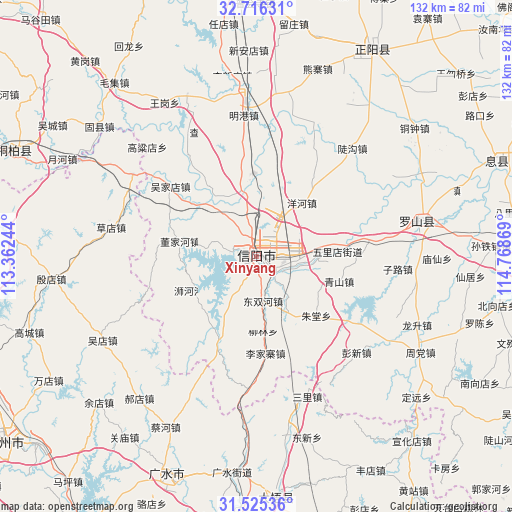
Xinyang GPS coordinates[2]
32° 7' 22.008" North, 114° 3' 56.016" East
| Map corner | latitude | longitude |
|---|---|---|
| Upper-left | 32.71631°, | 113.36244° |
| Center: | 32.12278°, | 114.06556° |
| Lower-right: | 31.52536°, | 114.76869° |
| Map W x H: | 132.4×132.4 km | = 82.3×82.3mi |
| max Lat: | 53.31946° ⇑38% North |
| Xinyang: | 32.12278° |
| min Lat: | ⇓62% South 18.22056° |
| min Long | Xinyang | max Long |
| 75.07348° | 114.06556° | 134.28917° |
| W 49.1%⇐ | ⇒50.9% E |
Elevation
Elevation of Xinyang is 89 m = 292 ft, and this is 395.8 m = 1299 ft below average elevation for this country.
| Max E: |
5622 m = 18445 ft | 61.7% |
| Avg. | 484.8 m = 1591 ft | |
| Xinyang | 89 m = 292 ft | |
Min E: |
-3 m = -10 ft | 38.3% |
See also: Xinyang elevation on elevation.city.
Geographical zone
Xinyang is located in North temperate zone (between Tropic of Cancer and the Arctic Circle). Distance of this Northern Tropic circle is 965.8 km =600.1 mi to South.| Distance of | km | miles | from Xinyang |
|---|---|---|---|
| North Pole | 6435.3 | 3998.7 | to North |
| Arctic Circle | 3829.5 | 2379.5 | to North |
| Tropic Cancer | 965.8 | 600.1 | to South |
| Equator | 3571.7 | 2219.4 | to South |


Nearby cities:
15 places around Xinyang: (largest is in red/bold)
• Caihe
50.2 km =31.2 mi,  208°
208°
• Caodian
38.3 km =23.8 mi,  281°
281°
• Daxin
45.4 km =28.2 mi,  169°
169°
• Dongxin
48.6 km =30.2 mi,  163°
163°
• Haodian
47.5 km =29.5 mi,  219°
219°
• Huaihe
51.3 km =31.9 mi,  298°
298°
• Luoshan Chengguanzhen
42.7 km =26.5 mi,  77°
77°
• Minggang
37.4 km =23.2 mi,  357°
357°
• Pingqiao
6 km =3.7 mi,  120°
120°
• Sanlicheng
38.2 km =23.7 mi, 160°
• Tanjiahe
26.3 km =16.3 mi,  201°
201°
• Wudian
45.4 km =28.2 mi,  241°
241°
• Wushengguan
49.6 km =30.8 mi,  182°
182°
• Xiaolin
38.7 km =24 mi, 303°
• Yindian
53 km =32.9 mi,  263°
263°
Sources, notices
• [Note1] Compared only with cities in China existing in our database
• [Src1] Map data: © OpenStreetMap contributors (CC-BY-SA)
• [Src2] Other city data from geonames.org with taken over terms of usage.
• [Src3] Geographical zone / Annual Mean Temperature by Robert A. Rohde @ Wikipedia
