Tanjiahe geodata
Tanjiahe (Henan) is a seat of a fourth-order administrative division; located in China in Asia/Shanghai (GMT+8) time zone. In our database, there are 1268 cities with bigger population. Compared to other cities in China, 60.6% of cities are located further ↓South; 51.6% of cities are located further →East and 57.5% of cities have higher elevation than Tanjiahe. Note1


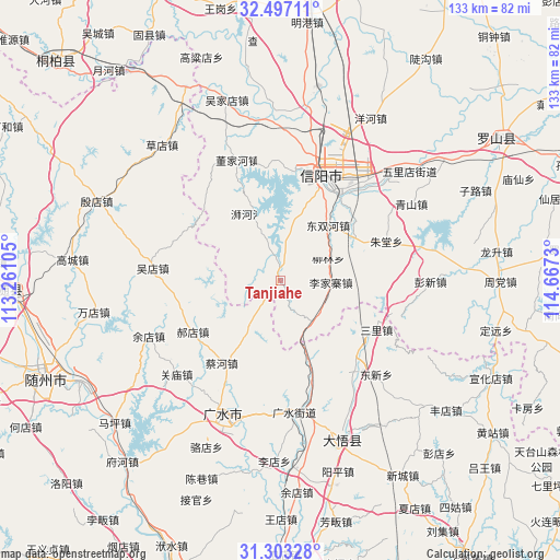
Tanjiahe GPS coordinates[2]
31° 54' 7.668" North, 113° 57' 51.012" East
| Map corner | latitude | longitude |
|---|---|---|
| Upper-left | 32.49711°, | 113.26105° |
| Center: | 31.90213°, | 113.96417° |
| Lower-right: | 31.30328°, | 114.6673° |
| Map W x H: | 132.7×132.7 km | = 82.5×82.5mi |
| max Lat: | 53.31946° ⇑39.4% North |
| Tanjiahe: | 31.90213° |
| min Lat: | ⇓60.6% South 18.22056° |
| min Long | Tanjiahe | max Long |
| 75.07348° | 113.96417° | 134.28917° |
| W 48.4%⇐ | ⇒51.6% E |
Elevation
Elevation of Tanjiahe is 114 m = 374 ft, and this is 370.8 m = 1217 ft below average elevation for this country.
| Max E: |
5622 m = 18445 ft | 57.5% |
| Avg. | 484.8 m = 1591 ft | |
| Tanjiahe | 114 m = 374 ft | |
Min E: |
-3 m = -10 ft | 42.5% |
See also: China elevation on elevation.city.
Geographical zone
Tanjiahe is located in North temperate zone (between Tropic of Cancer and the Arctic Circle). Distance of this Northern Tropic circle is 941.3 km =584.9 mi to South.| Distance of | km | miles | from Tanjiahe |
|---|---|---|---|
| North Pole | 6459.9 | 4014 | to North |
| Arctic Circle | 3854 | 2394.8 | to North |
| Tropic Cancer | 941.3 | 584.9 | to South |
| Equator | 3547.2 | 2204.1 | to South |


Nearby cities:
15 places around Tanjiahe: (largest is in red/bold)
• Baolin
26.9 km =16.7 mi,  199°
199°
• Caihe
24.3 km =15.1 mi,  216°
216°
• Dawu Chengguanzhen
35.6 km =22.1 mi,  155°
155°
• Daxin
26.9 km =16.7 mi,  138°
138°
• Dongxin
32 km =19.9 mi,  133°
133°
• Guangshui
31.5 km =19.6 mi,  174°
174°
• Guanmiao
32.9 km =20.4 mi,  228°
228°
• Haodian
24 km =14.9 mi,  239°
239°
• Pingqiao
26.1 km =16.2 mi,  34°
34°
• Sanlicheng
25.3 km =15.7 mi,  116°
116°
• Shili
33 km =20.5 mi,  193°
193°
• Wudian
30.5 km =19 mi,  275°
275°
• Wushengguan
26 km =16.2 mi, 164°
• Xinyang
26.3 km =16.3 mi,  21°
21°
• Yudian
33.8 km =21 mi,  247°
247°
Sources, notices
• [Note1] Compared only with cities in China existing in our database
• [Src1] Map data: © OpenStreetMap contributors (CC-BY-SA)
• [Src2] Other city data from geonames.org with taken over terms of usage.
• [Src3] Geographical zone / Annual Mean Temperature by Robert A. Rohde @ Wikipedia
