Minggang geodata
Minggang (Henan) is a populated place; located in China in Asia/Shanghai (GMT+8) time zone. With population of 67,945 people, there are 630 cities with bigger population in this country. Compared to other cities in China, 63.8% of cities are located further ↓South; 51% of cities are located further →East and 63.9% of cities have higher elevation than Minggang. Note1


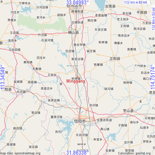
Minggang GPS coordinates[2]
32° 27' 30.996" North, 114° 2' 54.996" East
| Map corner | latitude | longitude |
|---|---|---|
| Upper-left | 33.04993°, | 113.34549° |
| Center: | 32.45861°, | 114.04861° |
| Lower-right: | 31.86338°, | 114.75174° |
| Map W x H: | 131.9×131.9 km | = 82×82mi |
| max Lat: | 53.31946° ⇑36.2% North |
| Minggang: | 32.45861° |
| min Lat: | ⇓63.8% South 18.22056° |
| min Long | Minggang | max Long |
| 75.07348° | 114.04861° | 134.28917° |
| W 49%⇐ | ⇒51% E |
Elevation
Elevation of Minggang is 78 m = 256 ft, and this is 406.8 m = 1335 ft below average elevation for this country.
| Max E: |
5622 m = 18445 ft | 63.9% |
| Avg. | 484.8 m = 1591 ft | |
| Minggang | 78 m = 256 ft | |
Min E: |
-3 m = -10 ft | 36.1% |
See also: Minggang elevation on elevation.city.
Geographical zone
Minggang is located in North temperate zone (between Tropic of Cancer and the Arctic Circle). Distance of this Northern Tropic circle is 1003.1 km =623.3 mi to South.| Distance of | km | miles | from Minggang |
|---|---|---|---|
| North Pole | 6398 | 3975.5 | to North |
| Arctic Circle | 3792.1 | 2356.3 | to North |
| Tropic Cancer | 1003.1 | 623.3 | to South |
| Equator | 3609.1 | 2242.6 | to South |


Nearby cities:
15 places around Minggang: (largest is in red/bold)
• Caodian
46.4 km =28.8 mi,  230°
230°
• Huaihe
45 km =28 mi,  253°
253°
• Laohe
60 km =37.3 mi,  328°
328°
• Liuge
58.9 km =36.6 mi,  353°
353°
• Luoshan Chengguanzhen
51.8 km =32.2 mi,  123°
123°
• Magutian
58.9 km =36.6 mi,  293°
293°
• Panlong
38.3 km =23.8 mi,  355°
355°
• Pingqiao
40.9 km =25.4 mi,  170°
170°
• Tanjiahe
62.4 km =38.8 mi,  187°
187°
• Tongbai Chengguanzhen
62.1 km =38.6 mi,  260°
260°
• Tongshan
57.8 km =35.9 mi,  307°
307°
• Xiaolin
34.6 km =21.5 mi,  242°
242°
• Xinyang
37.4 km =23.2 mi,  177°
177°
• Zhenyang
35.3 km =21.9 mi,  62°
62°
• Zhumadian
57.9 km =36 mi, 358°
Sources, notices
• [Note1] Compared only with cities in China existing in our database
• [Src1] Map data: © OpenStreetMap contributors (CC-BY-SA)
• [Src2] Other city data from geonames.org with taken over terms of usage.
• [Src3] Geographical zone / Annual Mean Temperature by Robert A. Rohde @ Wikipedia
