Wushengguan geodata
Wushengguan (Hubei) is a seat of a fourth-order administrative division; located in China in Asia/Shanghai (GMT+8) time zone. In our database, there are 1268 cities with bigger population. Compared to other cities in China, 59.4% of cities are located further ↓South; 51.1% of cities are located further →East and 62.4% of cities have higher elevation than Wushengguan. Note1


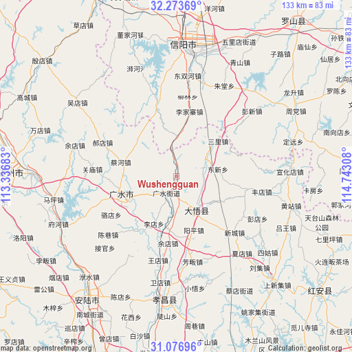
Wushengguan GPS coordinates[2]
31° 40' 38.1" North, 114° 2' 23.82" East
| Map corner | latitude | longitude |
|---|---|---|
| Upper-left | 32.27369°, | 113.33683° |
| Center: | 31.67725°, | 114.03995° |
| Lower-right: | 31.07696°, | 114.74308° |
| Map W x H: | 133.1×133.1 km | = 82.7×82.7mi |
| max Lat: | 53.31946° ⇑40.6% North |
| Wushengguan: | 31.67725° |
| min Lat: | ⇓59.4% South 18.22056° |
| min Long | Wushengguan | max Long |
| 75.07348° | 114.03995° | 134.28917° |
| W 48.9%⇐ | ⇒51.1% E |
Elevation
Elevation of Wushengguan is 85 m = 279 ft, and this is 399.8 m = 1312 ft below average elevation for this country.
| Max E: |
5622 m = 18445 ft | 62.4% |
| Avg. | 484.8 m = 1591 ft | |
| Wushengguan | 85 m = 279 ft | |
Min E: |
-3 m = -10 ft | 37.6% |
See also: China elevation on elevation.city.
Geographical zone
Wushengguan is located in North temperate zone (between Tropic of Cancer and the Arctic Circle). Distance of this Northern Tropic circle is 916.3 km =569.4 mi to South.| Distance of | km | miles | from Wushengguan |
|---|---|---|---|
| North Pole | 6484.9 | 4029.5 | to North |
| Arctic Circle | 3879 | 2410.3 | to North |
| Tropic Cancer | 916.3 | 569.4 | to South |
| Equator | 3522.2 | 2188.6 | to South |


Nearby cities:
15 places around Wushengguan: (largest is in red/bold)
• Baolin
16.1 km =10 mi,  268°
268°
• Caihe
22.1 km =13.7 mi,  284°
284°
• Dawu Chengguanzhen
10.5 km =6.5 mi,  135°
135°
• Daxin
11.8 km =7.3 mi,  65°
65°
• Dongxin
16.1 km =10 mi,  79°
79°
• Gaodian
20.3 km =12.6 mi,  118°
118°
• Guangshui
7.5 km =4.7 mi,  212°
212°
• Luodian
28.6 km =17.8 mi,  239°
239°
• Sanlicheng
20.6 km =12.8 mi,  48°
48°
• Shili
16.7 km =10.4 mi,  245°
245°
• Taiping
27.1 km =16.8 mi,  204°
204°
• Tanjiahe
26 km =16.2 mi,  344°
344°
• Xincheng
30.1 km =18.7 mi,  134°
134°
• Yangping
21 km =13 mi,  161°
161°
• Yangzhai
20.6 km =12.8 mi,  186°
186°
Sources, notices
• [Note1] Compared only with cities in China existing in our database
• [Src1] Map data: © OpenStreetMap contributors (CC-BY-SA)
• [Src2] Other city data from geonames.org with taken over terms of usage.
• [Src3] Geographical zone / Annual Mean Temperature by Robert A. Rohde @ Wikipedia
