Xinji geodata
Xinji (Hebei) is a populated place; located in China in Asia/Shanghai (GMT+8) time zone. With population of 145,911 people, there are 306 cities with bigger population in this country. Compared to other cities in China, 80.8% of cities are located further ↓South; 55.4% of cities are located further ←West and 73.7% of cities have higher elevation than Xinji. Note1


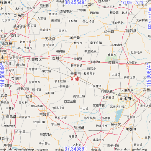
Xinji GPS coordinates[2]
37° 54' 10.008" North, 115° 12' 12.996" East
| Map corner | latitude | longitude |
|---|---|---|
| Upper-left | 38.45549°, | 114.50049° |
| Center: | 37.90278°, | 115.20361° |
| Lower-right: | 37.34589°, | 115.90674° |
| Map W x H: | 123.4×123.4 km | = 76.7×76.7mi |
| max Lat: | 53.31946° ⇑19.2% North |
| Xinji: | 37.90278° |
| min Lat: | ⇓80.8% South 18.22056° |
| min Long | Xinji | max Long |
| 75.07348° | 115.20361° | 134.28917° |
| W 55.4%⇐ | ⇒44.6% E |
Elevation
Elevation of Xinji is 40 m = 131 ft, and this is 444.8 m = 1459 ft below average elevation for this country.
| Max E: |
5622 m = 18445 ft | 73.7% |
| Avg. | 484.8 m = 1591 ft | |
| Xinji | 40 m = 131 ft | |
Min E: |
-3 m = -10 ft | 26.3% |
See also: Xinji elevation on elevation.city.
Geographical zone
Xinji is located in North temperate zone (between Tropic of Cancer and the Arctic Circle). Distance of this Northern Tropic circle is 1608.5 km =999.5 mi to South.| Distance of | km | miles | from Xinji |
|---|---|---|---|
| North Pole | 5792.7 | 3599.4 | to North |
| Arctic Circle | 3186.8 | 1980.2 | to North |
| Tropic Cancer | 1608.5 | 999.5 | to South |
| Equator | 4214.4 | 2618.7 | to South |


Nearby cities:
15 places around Xinji: (largest is in red/bold)
• Beile
49.2 km =30.6 mi,  283°
283°
• Beisu
44.6 km =27.7 mi,  308°
308°
• Donghoufang
41 km =25.5 mi,  319°
319°
• Gangshang
47.9 km =29.8 mi,  289°
289°
• Guozhuang
45.4 km =28.2 mi, 319°
• Haozhuang
37.3 km =23.2 mi,  301°
301°
• Hengshui
47.6 km =29.6 mi,  113°
113°
• Jiumen
47.3 km =29.4 mi, 298°
• Lichengdao
44.3 km =27.5 mi,  326°
326°
• Luancheng
48.5 km =30.1 mi,  266°
266°
• Nandong
44.9 km =27.9 mi, 299°
• Nanmeng
50.4 km =31.3 mi, 311°
• Xing’an
28.3 km =17.6 mi, 296°
• Zhangduangu
34.3 km =21.3 mi, 318°
• Zhoutou
16.5 km =10.3 mi, 273°
Sources, notices
• [Note1] Compared only with cities in China existing in our database
• [Src1] Map data: © OpenStreetMap contributors (CC-BY-SA)
• [Src2] Other city data from geonames.org with taken over terms of usage.
• [Src3] Geographical zone / Annual Mean Temperature by Robert A. Rohde @ Wikipedia
