Xingang geodata
Xingang (Jiangxi) is a seat of a fourth-order administrative division; located in China in Asia/Shanghai (GMT+8) time zone. In our database, there are 1268 cities with bigger population. Compared to other cities in China, 56.8% of cities are located further ↑North; 60.6% of cities are located further ←West and 81.2% of cities have higher elevation than Xingang. Note1


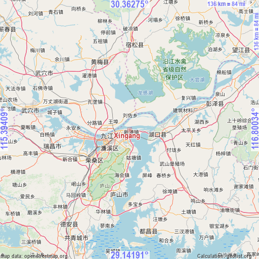
Xingang GPS coordinates[2]
29° 45' 15.084" North, 116° 5' 49.956" East
| Map corner | latitude | longitude |
|---|---|---|
| Upper-left | 30.36275°, | 115.39409° |
| Center: | 29.75419°, | 116.09721° |
| Lower-right: | 29.14191°, | 116.80034° |
| Map W x H: | 135.7×135.7 km | = 84.3×84.3mi |
| max Lat: | 53.31946° ⇑56.8% North |
| Xingang: | 29.75419° |
| min Lat: | ⇓43.2% South 18.22056° |
| min Long | Xingang | max Long |
| 75.07348° | 116.09721° | 134.28917° |
| W 60.6%⇐ | ⇒39.4% E |
Elevation
Elevation of Xingang is 24 m = 79 ft, and this is 460.8 m = 1512 ft below average elevation for this country.
| Max E: |
5622 m = 18445 ft | 81.2% |
| Avg. | 484.8 m = 1591 ft | |
| Xingang | 24 m = 79 ft | |
Min E: |
-3 m = -10 ft | 18.8% |
See also: China elevation on elevation.city.
Geographical zone
Xingang is located in North temperate zone (between Tropic of Cancer and the Arctic Circle). Distance of this Northern Tropic circle is 702.4 km =436.5 mi to South.| Distance of | km | miles | from Xingang |
|---|---|---|---|
| North Pole | 6698.7 | 4162.4 | to North |
| Arctic Circle | 4092.8 | 2543.1 | to North |
| Tropic Cancer | 702.4 | 436.5 | to South |
| Equator | 3308.4 | 2055.7 | to South |


Nearby cities:
15 places around Xingang: (largest is in red/bold)
• Chengshan
23 km =14.3 mi,  137°
137°
• Fenlu
19.2 km =11.9 mi,  281°
281°
• Gutang
14.9 km =9.3 mi,  172°
172°
• Huangcun
21.6 km =13.4 mi,  85°
85°
• Huikou
16 km =9.9 mi,  63°
63°
• Jiangzhou
4.3 km =2.7 mi,  30°
30°
• Jiujiang
10.7 km =6.6 mi,  239°
239°
• Lianhua
17 km =10.6 mi,  222°
222°
• Liuzuo
7.6 km =4.7 mi,  0°
0°
• Maying
19.1 km =11.9 mi,  99°
99°
• Shuangzhong
12.3 km =7.6 mi, 95°
• Wenqiao
22 km =13.7 mi,  117°
117°
• Xiaochi
10.4 km =6.5 mi,  269°
269°
• Yujiahe
9.1 km =5.7 mi,  212°
212°
• Zhangqing
23.1 km =14.4 mi, 100°
Sources, notices
• [Note1] Compared only with cities in China existing in our database
• [Src1] Map data: © OpenStreetMap contributors (CC-BY-SA)
• [Src2] Other city data from geonames.org with taken over terms of usage.
• [Src3] Geographical zone / Annual Mean Temperature by Robert A. Rohde @ Wikipedia
