Liuzuo geodata
Liuzuo (Hubei) is a seat of a fourth-order administrative division; located in China in Asia/Shanghai (GMT+8) time zone. In our database, there are 1268 cities with bigger population. Compared to other cities in China, 56.1% of cities are located further ↑North; 60.6% of cities are located further ←West and 84.3% of cities have higher elevation than Liuzuo. Note1


Liuzuo GPS coordinates[2]
29° 49' 22.656" North, 116° 5' 50.28" East
| Map corner | latitude | longitude |
|---|---|---|
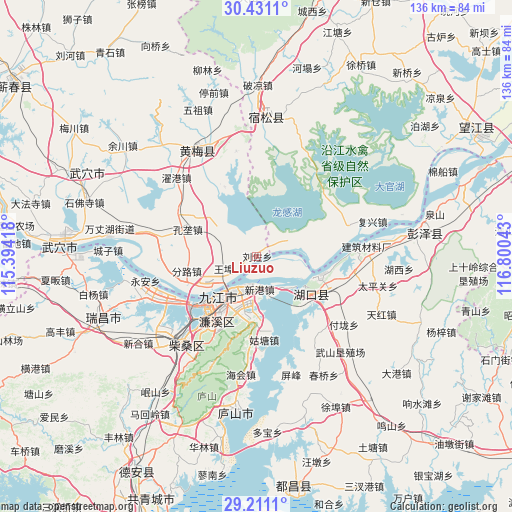
| Upper-left | 30.4311°, | 115.39418° |
| Center: | 29.82296°, | 116.0973° |
| Lower-right: | 29.2111°, | 116.80043° |
| Map W x H: | 135.7×135.7 km | = 84.3×84.3mi |
| max Lat: | 53.31946° ⇑56.1% North |
| Liuzuo: | 29.82296° |
| min Lat: | ⇓43.9% South 18.22056° |
| min Long | Liuzuo | max Long |
| 75.07348° | 116.0973° | 134.28917° |
| W 60.6%⇐ | ⇒39.4% E |
Elevation
Elevation of Liuzuo is 17 m = 56 ft, and this is 467.8 m = 1535 ft below average elevation for this country.
| Max E: |
5622 m = 18445 ft | 84.3% |
| Avg. | 484.8 m = 1591 ft | |
| Liuzuo | 17 m = 56 ft | |
Min E: |
-3 m = -10 ft | 15.7% |
See also: China elevation on elevation.city.
Geographical zone
Liuzuo is located in North temperate zone (between Tropic of Cancer and the Arctic Circle). Distance of this Northern Tropic circle is 710.1 km =441.2 mi to South.| Distance of | km | miles | from Liuzuo |
|---|---|---|---|
| North Pole | 6691.1 | 4157.7 | to North |
| Arctic Circle | 4085.2 | 2538.4 | to North |
| Tropic Cancer | 710.1 | 441.2 | to South |
| Equator | 3316 | 2060.5 | to South |


Nearby cities:
15 places around Liuzuo: (largest is in red/bold)
• Fenlu
19.2 km =11.9 mi,  258°
258°
• Gutang
22.5 km =14 mi,  174°
174°
• Huangcun
22.3 km =13.9 mi,  105°
105°
• Huikou
14.3 km =8.9 mi,  92°
92°
• Jiangzhou
4.5 km =2.8 mi,  150°
150°
• Jiujiang
16 km =9.9 mi,  214°
214°
• Konglong
20 km =12.4 mi,  290°
290°
• Lianhua
23.2 km =14.4 mi, 209°
• Maying
21.7 km =13.5 mi,  120°
120°
• Shuangzhong
15.1 km =9.4 mi,  125°
125°
• Xiaochi
12.9 km =8 mi,  233°
233°
• Xiaxin
20.5 km =12.7 mi,  334°
334°
• Xingang
7.6 km =4.7 mi,  180°
180°
• Yujiahe
16.1 km =10 mi,  197°
197°
• Zhoutou
21.8 km =13.5 mi,  77°
77°
Sources, notices
• [Note1] Compared only with cities in China existing in our database
• [Src1] Map data: © OpenStreetMap contributors (CC-BY-SA)
• [Src2] Other city data from geonames.org with taken over terms of usage.
• [Src3] Geographical zone / Annual Mean Temperature by Robert A. Rohde @ Wikipedia
