Xiaochi geodata
Xiaochi (Hubei) is a seat of a fourth-order administrative division; located in China in Asia/Shanghai (GMT+8) time zone. In our database, there are 1268 cities with bigger population. Compared to other cities in China, 56.8% of cities are located further ↑North; 60% of cities are located further ←West and 83.4% of cities have higher elevation than Xiaochi. Note1


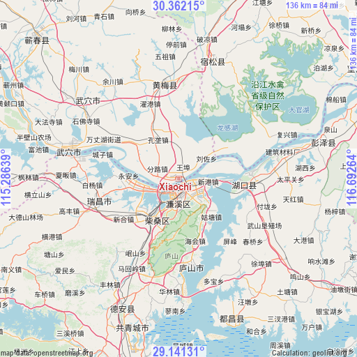
Xiaochi GPS coordinates[2]
29° 45' 12.924" North, 115° 59' 22.236" East
| Map corner | latitude | longitude |
|---|---|---|
| Upper-left | 30.36215°, | 115.28639° |
| Center: | 29.75359°, | 115.98951° |
| Lower-right: | 29.14131°, | 116.69264° |
| Map W x H: | 135.7×135.7 km | = 84.3×84.3mi |
| max Lat: | 53.31946° ⇑56.8% North |
| Xiaochi: | 29.75359° |
| min Lat: | ⇓43.2% South 18.22056° |
| min Long | Xiaochi | max Long |
| 75.07348° | 115.98951° | 134.28917° |
| W 60%⇐ | ⇒40% E |
Elevation
Elevation of Xiaochi is 19 m = 62 ft, and this is 465.8 m = 1528 ft below average elevation for this country.
| Max E: |
5622 m = 18445 ft | 83.4% |
| Avg. | 484.8 m = 1591 ft | |
| Xiaochi | 19 m = 62 ft | |
Min E: |
-3 m = -10 ft | 16.6% |
See also: China elevation on elevation.city.
Geographical zone
Xiaochi is located in North temperate zone (between Tropic of Cancer and the Arctic Circle). Distance of this Northern Tropic circle is 702.4 km =436.5 mi to South.| Distance of | km | miles | from Xiaochi |
|---|---|---|---|
| North Pole | 6698.8 | 4162.4 | to North |
| Arctic Circle | 4092.9 | 2543.2 | to North |
| Tropic Cancer | 702.4 | 436.5 | to South |
| Equator | 3308.3 | 2055.7 | to South |


Nearby cities:
15 places around Xiaochi: (largest is in red/bold)
• Fenlu
9.3 km =5.8 mi,  294°
294°
• Gangkoujie
20.3 km =12.6 mi,  261°
261°
• Guling
20.6 km =12.8 mi,  183°
183°
• Gutang
19.2 km =11.9 mi,  139°
139°
• Jiangzhou
13.2 km =8.2 mi,  73°
73°
• Jiujiang
5.6 km =3.5 mi,  167°
167°
• Konglong
17 km =10.6 mi,  330°
330°
• Lianhua
12.6 km =7.8 mi, 184°
• Liuzuo
12.9 km =8 mi,  53°
53°
• Saiyang
20.4 km =12.7 mi,  197°
197°
• Shahejie
19 km =11.8 mi,  211°
211°
• Xingang
10.4 km =6.5 mi,  89°
89°
• Xinkai
18.5 km =11.5 mi, 290°
• Yong’an
19.3 km =12 mi,  273°
273°
• Yujiahe
9.4 km =5.8 mi, 144°
Sources, notices
• [Note1] Compared only with cities in China existing in our database
• [Src1] Map data: © OpenStreetMap contributors (CC-BY-SA)
• [Src2] Other city data from geonames.org with taken over terms of usage.
• [Src3] Geographical zone / Annual Mean Temperature by Robert A. Rohde @ Wikipedia
